Approximate Location Map
Large Map »
Latitude: 51.1541 / 51°9'14"N
Longitude: 0.7049 / 0°42'17"E
OS Eastings: 589260
OS Northings: 142903
OS Grid: TQ892429
Mapcode National: GBR QV4.K25
Mapcode Global: VHKKK.58J3
Plus Code: 9F325P33+JX
Entry Name: Dering Farmhouse
Listing Date: 10 October 1980
Grade: II
Source: Historic England
Source ID: 1325169
English Heritage Legacy ID: 181222
ID on this website: 101325169
Location: Biddenden Green, Ashford, Kent, TN27
County: Kent
District: Ashford
Civil Parish: Smarden
Traditional County: Kent
Lieutenancy Area (Ceremonial County): Kent
Tagged with: Farmhouse
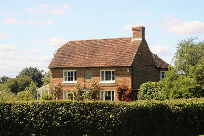
1.
5272 SMARDEN PLUCKLEY
Dering Farmhouse
TQ 8942 29/39
II
2.
C18 L-shaped house. Two storeys red brick. Two windows and one window space,
the window space filled with grey headers. Two 3-light sashes with vertical
glazing bars only. Half-hipped tiled roof. Doorcase with flat hood over.
Roof in 2 hips to rear.
Listing NGR: TQ8926042903
External links are from the relevant listing authority and, where applicable, Wikidata. Wikidata IDs may be related buildings as well as this specific building. If you want to add or update a link, you will need to do so by editing the Wikidata entry.


Other nearby listed buildings
