Approximate Location Map
Large Map »
Latitude: 54.402 / 54°24'7"N
Longitude: -2.5997 / 2°35'58"W
OS Eastings: 361167
OS Northings: 500893
OS Grid: NY611008
Mapcode National: GBR BK8J.ZR
Mapcode Global: WH93Q.1MB6
Plus Code: 9C6VCC22+R4
Entry Name: Salterwath Bridge over River Lune to South of Low Borrowbridge
Listing Date: 24 June 1987
Grade: II
Source: Historic England
Source ID: 1326772
English Heritage Legacy ID: 74197
ID on this website: 101326772
Location: Westmorland and Furness, Cumbria, CA10
County: Cumbria
District: Eden
Civil Parish: Tebay
Traditional County: Westmorland
Lieutenancy Area (Ceremonial County): Cumbria
Church of England Parish: Orton with Tebay All Saints
Church of England Diocese: Carlisle
Tagged with: Bridge
TEBAY
NY 60 SW
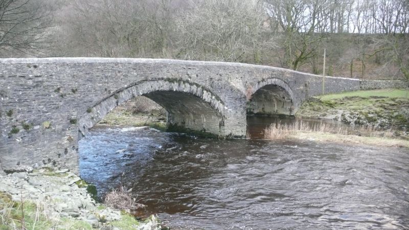
17/183 Salterwath bridge
over River Lune to
south of Low
Borrowbridge
II
Roadbridge. Rebuilt 1824 by Robert Gowling. Slobbered, coursed, squared rubble
with segmental copings. Splayed ends to parapets. 2 segmental arches, each of
c.4 ft span, separated by cutwater. Roadway c.20 ft wide with parapets c.3 ft
high.
Listing NGR: NY6116700893
External links are from the relevant listing authority and, where applicable, Wikidata. Wikidata IDs may be related buildings as well as this specific building. If you want to add or update a link, you will need to do so by editing the Wikidata entry.


