Approximate Location Map
Large Map »
Latitude: 54.6074 / 54°36'26"N
Longitude: -2.7477 / 2°44'51"W
OS Eastings: 351803
OS Northings: 523840
OS Grid: NY518238
Mapcode National: GBR 9H75.Y4
Mapcode Global: WH81J.RGS7
Plus Code: 9C6VJ742+XW
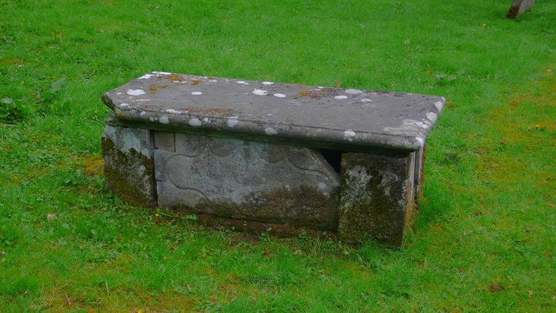
Entry Name: Chest Tomb to West of Path Approximately 24.5 Metres to South of St Peters Church
Listing Date: 31 January 1991
Grade: II
Source: Historic England
Source ID: 1326813
English Heritage Legacy ID: 74407
ID on this website: 101326813
Location: St Peter's Church, Askham, Westmorland and Furness, Cumbria, CA10
County: Cumbria
District: Eden
Civil Parish: Askham
Traditional County: Westmorland
Lieutenancy Area (Ceremonial County): Cumbria
Church of England Parish: Askham with Lowther
Church of England Diocese: Carlisle
Tagged with: Chest tomb
ASKHAM
NY 5023
NY 5123
Chest tomb to west of
16/10 path approximately 24.5 m
to south of St Peter's
Church (q.v.)
GV II
Chest tomb. Mid to late C18. Ashlar. Shaped incised panels to sides. Top
slab has moulded edge and illegible inscription.
Listing NGR: NY5180323840
External links are from the relevant listing authority and, where applicable, Wikidata. Wikidata IDs may be related buildings as well as this specific building. If you want to add or update a link, you will need to do so by editing the Wikidata entry.


Other nearby listed buildings
