Approximate Location Map
Large Map »
Latitude: 54.7006 / 54°42'2"N
Longitude: -3.3229 / 3°19'22"W
OS Eastings: 314842
OS Northings: 534759
OS Grid: NY148347
Mapcode National: GBR 5G72.DR
Mapcode Global: WH6ZQ.X3TR
Plus Code: 9C6RPM2G+7R
Entry Name: Blindcrake Hall
Listing Date: 3 March 1967
Grade: II
Source: Historic England
Source ID: 1326865
English Heritage Legacy ID: 72539
ID on this website: 101326865
Location: Blindcrake, Cumberland, Cumbria, CA13
County: Cumbria
District: Allerdale
Civil Parish: Blindcrake
Traditional County: Cumberland
Lieutenancy Area (Ceremonial County): Cumbria
Church of England Parish: Binsey Team
Church of England Diocese: Carlisle
Tagged with: House
BLINDCRAKE BLINDCRAKE
NY 13 SW
5/14 Blindcrake Hall
3-3-67
5/14 II
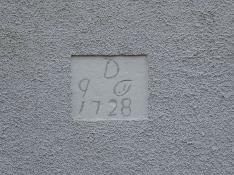
House. Dated and inscribed on rear datestone J & T.D. 1728. Painted roughcast
walls with V-jointed quoins, under graduated greenslate roof with brick chimney
stacks; rear extension with C20 tile roof. 2 storeys, 5 bays. Panelled door
and overlight in painted stone architrave. Sash windows with glazing bars in
painted stone architraves.
Listing NGR: NY1484234759
External links are from the relevant listing authority and, where applicable, Wikidata. Wikidata IDs may be related buildings as well as this specific building. If you want to add or update a link, you will need to do so by editing the Wikidata entry.


Other nearby listed buildings
