Approximate Location Map
Large Map »
Latitude: 54.5389 / 54°32'19"N
Longitude: -3.271 / 3°16'15"W
OS Eastings: 317863
OS Northings: 516699
OS Grid: NY178166
Mapcode National: GBR 5HLY.MQ
Mapcode Global: WH70J.Q5LR
Plus Code: 9C6RGPQH+GJ
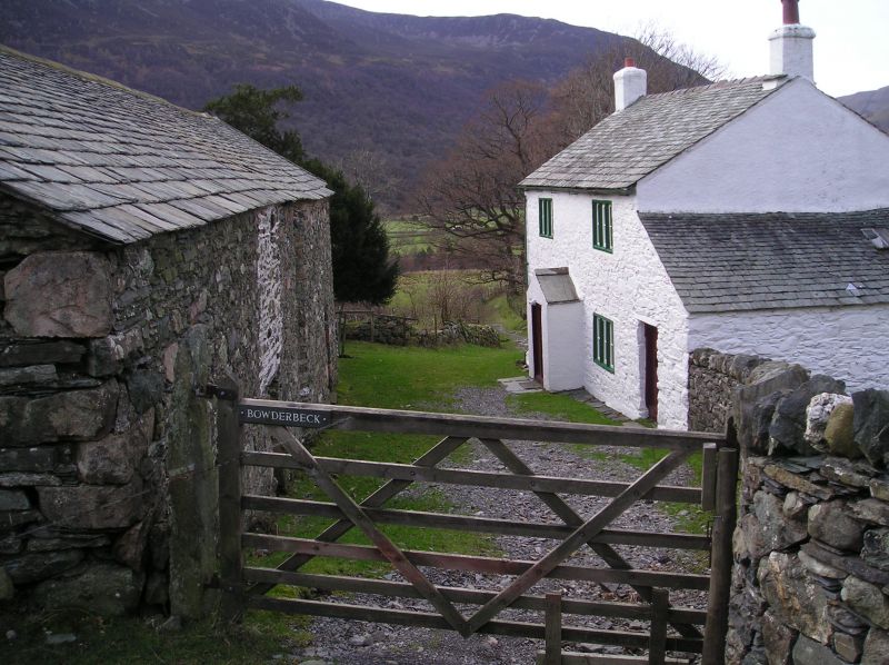
Entry Name: Bowderbeck
Listing Date: 8 August 1985
Grade: II
Source: Historic England
Source ID: 1327191
English Heritage Legacy ID: 72165
ID on this website: 101327191
Location: Buttermere, Cumberland, Cumbria, CA13
County: Cumbria
District: Allerdale
Civil Parish: Buttermere
Traditional County: Cumberland
Lieutenancy Area (Ceremonial County): Cumbria
Church of England Parish: Loweswater with Buttermere
Church of England Diocese: Carlisle
Tagged with: Building
NY 11 NE BUTTERMERE BUTTERMERE
14/81 Bowderbeck
II
Farmhouse. Late C17. Whitewashed rubble walls, under graduated greenslate roof
with roughcast chimney stacks. 2 storeys, 2 bays. C20 door in gabled stone
porch. 3-light chamfered stone-mullioned windows. Right-side lean-to has plank
door at front. Rear outshut has 2-light stone-mullioned windows.
Listing NGR: NY1786316699
External links are from the relevant listing authority and, where applicable, Wikidata. Wikidata IDs may be related buildings as well as this specific building. If you want to add or update a link, you will need to do so by editing the Wikidata entry.


Other nearby listed buildings
