Approximate Location Map
Large Map »
Latitude: 50.6154 / 50°36'55"N
Longitude: -4.5691 / 4°34'8"W
OS Eastings: 218340
OS Northings: 82666
OS Grid: SX183826
Mapcode National: GBR N9.BG6K
Mapcode Global: FRA 179F.ZQK
Plus Code: 9C2QJC8J+48
Entry Name: Footbridge and Pack Horse Bridge 200 Metres to South East of Bowithick
Listing Date: 23 November 1988
Grade: II
Source: Historic England
Source ID: 1328085
English Heritage Legacy ID: 68309
ID on this website: 101328085
Location: Bowithick, Cornwall, PL15
County: Cornwall
Civil Parish: Altarnun
Traditional County: Cornwall
Lieutenancy Area (Ceremonial County): Cornwall
Church of England Parish: Altarnon with Bolventor
Church of England Diocese: Truro
Tagged with: Footbridge Packhorse bridge
ALTARNUN BOWITHICK
SX 18 SE
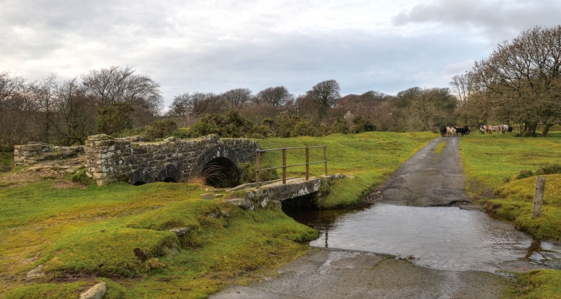
3/92 Footbridge and pack horse bridge
- 200 metres to south east of
Bowithick
GV II
Footbridge and remains of pack horse bridge. Probably early C19. The footbridge is
constructed of granite with a single granite lintel spanning the stream. The
packhorse bridge is constructed of stone rubble with a wide rounded dressed stone
arch and two narrower rounded dressed stone arches. The parapets have been reduced in
height.
Listing NGR: SX1834282665
External links are from the relevant listing authority and, where applicable, Wikidata. Wikidata IDs may be related buildings as well as this specific building. If you want to add or update a link, you will need to do so by editing the Wikidata entry.


Other nearby listed buildings
