Approximate Location Map
Large Map »
Latitude: 51.8716 / 51°52'17"N
Longitude: 0.3637 / 0°21'49"E
OS Eastings: 562820
OS Northings: 221870
OS Grid: TL628218
Mapcode National: GBR NGB.NR7
Mapcode Global: VHJJF.8731
Plus Code: 9F32V9C7+MF
Entry Name: Boar's Head Public House
Listing Date: 24 October 1979
Grade: II
Source: Historic England
Source ID: 1328239
English Heritage Legacy ID: 353290
ID on this website: 101328239
Location: Great Dunmow, Uttlesford, Essex, CM6
County: Essex
District: Uttlesford
Civil Parish: Great Dunmow
Built-Up Area: Great Dunmow
Traditional County: Essex
Lieutenancy Area (Ceremonial County): Essex
Church of England Parish: Great Dunmow St Mary the Virgin
Church of England Diocese: Chelmsford
Tagged with: Pub
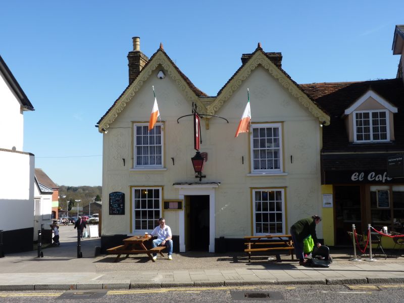
TL 6221 GREAT DUNMOW HIGH STREET (E side)
8/44 Boar's Head Public
24.10.79 House No. 37
GV II
Public House. C14, C16 and C19. 2 storey, timber framed and rendered with
4 gabled peg tile roofs. Front has 2 gables each with a double hung sash window
with g.b.'s and moulded architraves on each floor. Off-centre, early C19
pilastered doorcase with flat hood and old iron hanging sign brackets. C19
cusped decorative bargeboards to each gable and 3 gault brick stacks, 2 of which
project through the flank roofs. Elevation to White Street has 3 similar double
hung sashes and northwards projection of rear block. Interior reveals evidence
of 4 builds. Formerly jettied crosswing on NW corner with included cross
passage with wide stud spacing remnants of window in rear and heavy 'knee-like'
bracing to tie beam. C16 hall range parallel to street frontage with original
floor on moulded inpost, formerly jettied to front and roof rebuilt to form
gable. NE block is c.1500, floored with dragon beam and was formerly jettied
on E and S faces. Heavy crown post roof with 4 way bracing and chamfered post
and long curved braces to tie beam. Similar to rear structure at Chequers P.H.
S.E. corner block is C19 extension.
Listing NGR: TL6282021870
External links are from the relevant listing authority and, where applicable, Wikidata. Wikidata IDs may be related buildings as well as this specific building. If you want to add or update a link, you will need to do so by editing the Wikidata entry.


Other nearby listed buildings
