Approximate Location Map
Large Map »
Latitude: 50.5524 / 50°33'8"N
Longitude: -4.6632 / 4°39'47"W
OS Eastings: 211436
OS Northings: 75903
OS Grid: SX114759
Mapcode National: GBR N5.GG0Y
Mapcode Global: FRA 173L.YYY
Plus Code: 9C2QH82P+XP
Entry Name: Delford Bridge
Listing Date: 11 November 1987
Grade: II
Source: Historic England
Source ID: 1328276
English Heritage Legacy ID: 67295
ID on this website: 101328276
Location: Bradford, Cornwall, PL30
County: Cornwall
Civil Parish: Blisland
Traditional County: Cornwall
Lieutenancy Area (Ceremonial County): Cornwall
Church of England Parish: St Breward
Church of England Diocese: Truro
Tagged with: Road bridge
BLISLAND
SX 17 NW
6/9
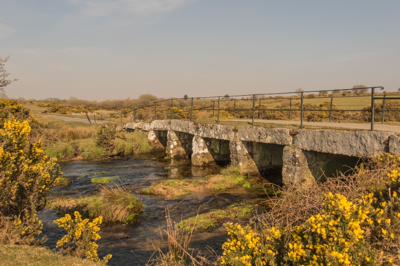
Delford Bridge
II
Road bridge of clapper construction over De Lank River and ford to south-east. Circa C19. Granite and moorstone. Five-span clapper bridge with ashlar granite lintels. Stone rubble piers, pointed to form cutwaters on east.
This entry was subject to a Minor Amendment on 26 September 2017.
External links are from the relevant listing authority and, where applicable, Wikidata. Wikidata IDs may be related buildings as well as this specific building. If you want to add or update a link, you will need to do so by editing the Wikidata entry.


Other nearby listed buildings
