Approximate Location Map
Large Map »
Latitude: 54.6165 / 54°36'59"N
Longitude: -1.2537 / 1°15'13"W
OS Eastings: 448292
OS Northings: 524854
OS Grid: NZ482248
Mapcode National: GBR MHP1.CW
Mapcode Global: WHD6S.Q767
Plus Code: 9C6WJP8W+JG
Entry Name: Hall's Farmhouse
Listing Date: 21 June 1985
Grade: II
Source: Historic England
Source ID: 1329833
English Heritage Legacy ID: 59214
ID on this website: 101329833
Location: Cowpen Bewley, Stockton-on-Tees, North Yorkshire, TS23
County: Stockton-on-Tees
Civil Parish: Billingham
Traditional County: Durham
Lieutenancy Area (Ceremonial County): County Durham
Church of England Parish: Billingham
Church of England Diocese: Durham
Tagged with: Farmhouse
NZ 4824 BILLINGHAM THE GREEN
(North side)
19/431 COWPEN BEWLEY
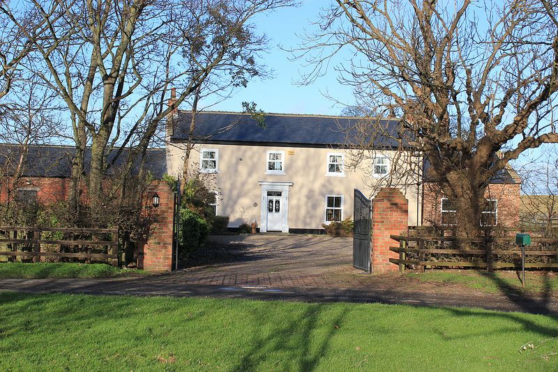
Hall's Farmhouse
II
Early C19. Late Georgian, possibly with earlier core. Double span house.
Roughcast (probably over brick) with Welsh slate roof. Two storeys, four windows
and a two-window wing. C19 sashes and casements. Four-panel door with oblong
fanlight in wood pilaster doorcase (also known as Manor Farm House).
Listing NGR: NZ4829224854
External links are from the relevant listing authority and, where applicable, Wikidata. Wikidata IDs may be related buildings as well as this specific building. If you want to add or update a link, you will need to do so by editing the Wikidata entry.


Other nearby listed buildings
