Latitude: 53.7194 / 53°43'9"N
Longitude: -1.8532 / 1°51'11"W
OS Eastings: 409787
OS Northings: 424781
OS Grid: SE097247
Mapcode National: GBR HTHF.LG
Mapcode Global: WHC9M.HSR1
Plus Code: 9C5WP49W+PP
Entry Name: Cantilevered Footpath and Weir on the East Bank of Hebble Brook
Listing Date: 1 July 1993
Grade: II
Source: Historic England
Source ID: 1330020
English Heritage Legacy ID: 447651
ID on this website: 101330020
Location: Halifax, Calderdale, West Yorkshire, HX3
County: Calderdale
Electoral Ward/Division: Town
Parish: Non Civil Parish
Built-Up Area: Halifax
Traditional County: Yorkshire
Lieutenancy Area (Ceremonial County): West Yorkshire
Church of England Parish: Halifax The Minster Church of St John the Baptist
Church of England Diocese: Leeds
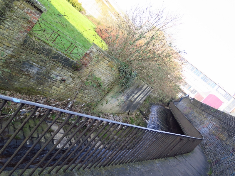
WATER SIDE
SE 0924 NE
679-/19/10024 Cantilevered Footpath
and Weir, on the east
bank of Hebble Brook
GV II
Cantilevered footpath, with walls and attached weir. c1830. Coursed rubble stone and
ashlar. This footpath runs from Lily Bridge on Waterside, north along the east bank
of Hebble Brook. The southern section, 45 metres in length has a low wall to the left
which drops to the brook, the right wall is 8 foot high with pyramidal coping. To
the north a curved weir and sluice with machinery intact. From this point the
footpath stretches north for 40 metres between two similar walls. Then it becomes
cantilevered with large stone slabs supported on curved stone brackets, with an iron
stick baluster railing on the left side. The northern most section has been replaced,
the brackets and some broken paving survives below the new concrete footpath and
bridge.
Listing NGR: SE0978724781
External links are from the relevant listing authority and, where applicable, Wikidata. Wikidata IDs may be related buildings as well as this specific building. If you want to add or update a link, you will need to do so by editing the Wikidata entry.


Other nearby listed buildings