Approximate Location Map
Large Map »
Latitude: 53.1444 / 53°8'39"N
Longitude: -2.3649 / 2°21'53"W
OS Eastings: 375691
OS Northings: 360872
OS Grid: SJ756608
Mapcode National: GBR 010.WFF
Mapcode Global: WH9B0.N727
Plus Code: 9C5V4JVP+Q3
Entry Name: Drinking Fountain
Listing Date: 27 April 1978
Grade: II
Source: Historic England
Source ID: 1330396
English Heritage Legacy ID: 56208
ID on this website: 101330396
Location: Sandbach, Cheshire East, Cheshire, CW11
County: Cheshire East
Civil Parish: Sandbach
Built-Up Area: Sandbach
Traditional County: Cheshire
Lieutenancy Area (Ceremonial County): Cheshire
Church of England Parish: Sandbach
Church of England Diocese: Chester
Tagged with: Drinking fountain
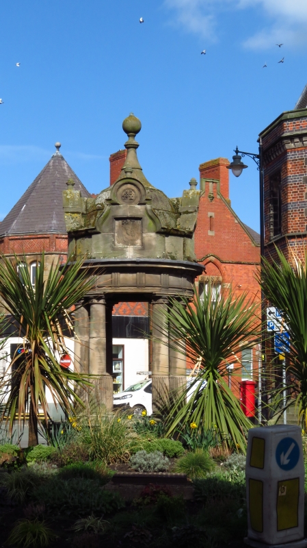
HIGHTOWN
1.
5144
(In the Centre)
Drinking Fountain
SJ 7560 1/63
II
2.
1897. By Thomas Bower, the architect of the Town Hall. Stone. Circular on plan,
the base with central basin having 4 projecting stoups and a ring of 8 Tuscan
columns supporting a shaped canopy with triglyph frieze, shaped gablets, and ball-headed
shaped pinnacle.
Listing NGR: SJ7569160871
External links are from the relevant listing authority and, where applicable, Wikidata. Wikidata IDs may be related buildings as well as this specific building. If you want to add or update a link, you will need to do so by editing the Wikidata entry.


Other nearby listed buildings
