Latitude: 52.3991 / 52°23'56"N
Longitude: 0.2588 / 0°15'31"E
OS Eastings: 553776
OS Northings: 280299
OS Grid: TL537802
Mapcode National: GBR M6H.D8P
Mapcode Global: VHHJ6.FYPQ
Plus Code: 9F4297X5+JG
Entry Name: 48 St Mary's Street
Listing Date: 12 December 1968
Last Amended: 18 November 2016
Grade: II
Source: Historic England
Source ID: 1331703
English Heritage Legacy ID: 48795
ID on this website: 101331703
Location: Ely, East Cambridgeshire, CB7
County: Cambridgeshire
District: East Cambridgeshire
Civil Parish: Ely
Built-Up Area: Ely
Traditional County: Cambridgeshire
Lieutenancy Area (Ceremonial County): Cambridgeshire
Church of England Parish: Ely
Church of England Diocese: Ely
Tagged with: Building
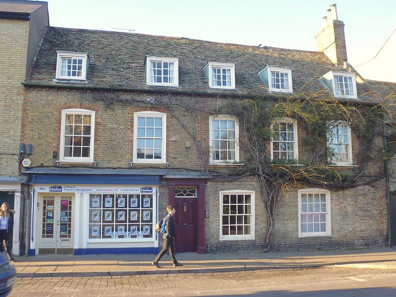
House of probable late C15 origin, altered in the C17, refronted in the C18, extended in the C19, and altered in the C20.
House of probable late-C15 origin, altered in the C17, re-fronted in the C18, extended in the C19, and altered in the C20.
MATERIALS: partial survival of timber frame, yellow stock brick with red brick dressings and plain clay tile roof covering.
PLAN: the building is part of a terrace and consists of a front range with a rectangular plan facing south-east onto St Mary’s Street, a C19 cross wing on the north-west end and a long C19 rear range running parallel on its south-west side.
EXTERIOR: the building has two storeys, an attic, and a cellar below the C19 cross wing. The pitched roof has a dentilled eaves cornice, and a parapet and tumbled in brickwork on the right (north-east) gable end, through which rises a wide brick chimney stack. The façade is five bays wide and has red brick quoins and a first-floor storey band. The two left bays of the ground floor are occupied by a C20 shop front in a simple neo-Classical style. The central bay contains the recessed, early C19 four-panelled front door which has raised and fielded upper panels and moulded lower panels. This is set in a doorcase which has pilasters with square capitals, panelled jambs, a plain frieze and a fanlight with a geometric glazing bar pattern. The C19 windows are set flush with the wall and have segmental brick arches. The two ground-floor bays to the right are lit by large eight-over-eight pane sash windows. On either side of the right-hand window is a bricked up window opening with a segmental brick arch. To the right again there is another bricked up opening which may have been a doorway, followed by part of the red brick surround of an archway which has also been bricked up. The first floor is lit by five six-over-six pane sashes which have brick surrounds and projecting decorative iron sills. The attic is lit by five flat-headed dormer windows with six-pane sliding sashes set wholly in the roof space.
Built against the north-east gable end is the archway (part of 46 St Mary’s Street) that provides access to the rear. To the right of the archway is the three-storey C19 cross wing which has no window openings. The gabled rear (north-west) elevation of this wing has plain bargeboards and is three window bays wide. There are two shallow arched basement openings, and the outer bays of the ground floor contain a door with a two-panelled lower section and glazed upper section with glazing bar margin-lights. The door on the left also has flanking margin-lights. The middle bay is lit by a large two-over-two pane sash window. These openings are cambered and have gauged brick arches, as do all the openings on this elevation. The outer bays of the first floor have full height casement windows with glazing bar margin lights and decorative cast iron balconies. The middle bay is lit by a two-over-two pane sash window, and the second floor by two windows in the same style.
The long, two-storey, brick rear range has been subject to much alteration and repair, and it has numerous blocked and altered openings. The windows are C20, as is a door at first-floor level, whilst the ground-floor door is C19. It was not possible (2016) to see the roof pitch or covering.
INTERIOR: the principal area of interest is the south-west (left) end of the house which retains late C15 fabric. In the ground-floor room (now commercial premises, 2016) the extant ceiling structure comprises a spine beam running laterally (north-east south-west) through the building with a series of joists of square profile which join in to the spine beam with spurred upper shoulder joints. The spine beam is elaborately moulded with a hollow chamfer and two rolls, above which it is further embellished with a series of crenellations. Neither end of the beam is stopped which could suggest that the full width of the bay is not currently visible. Above this room on the first floor the partial survival of two trusses are visible. The south-western most truss is represented by a partially exposed elbowed post at the north-western end which supports a cross beam. The truss to the north-east of this now comprises two elbowed posts and a remaining section of what appears to be the original collar beam. The north-western post is largely concealed by later plasterwork. A series of timber studs inserted south-east of the truss, supporting a beam which runs in line with the earlier collar, possibly date to the C17 alterations.
Few C18 or C19 fixtures or fittings remain in the house other than several four-panelled doors, and most of the plaster cornices do not appear to be original. The central front door opens into the entrance hall which leads to a self-contained flat on the right (north-east) and to the rear staircase hall in the cross wing. The open well, stripped pine stair has a panelled spandrel, carved tread ends, two slender turned balusters per tread, and a scrolled handrail supported by a decorative cast-iron newel post. On the first floor the three bays to the right (north-east) are occupied by a large drawing room which has a C17, chamfered, spine beam with a scrolled and notched stop. The unpainted, neo-Classical style fireplace and swan’s nest grate is not original to the house. The lower part of the roof structure is obscured by the inserted attic rooms but the upper section is visible and is of common rafter form, with the rafters meeting in a mortice and tenon joint pegged with a single central peg.
The rear range has been converted into ten flats and was not available for inspection (2016).
The present city of Ely rises 20m above the surrounding fen on an island of Kimmeridge clay. Although well connected by river and waterways, until the C17 only causeways connected the island to the mainland, and in the early years of Christianity its isolation made it an ideal refuge for those seeking a secluded monastic life. The first successful attempt to establish a religious settlement here was made by Etheldreda in c.673, re-endowed by King Edgar 100 years after its destruction by the Danes in 870. Despite threats of further invasion in the C11, and later political turmoil, this monastery survived until its dissolution in 1539. The presence of a monastic community occupying substantial buildings required the support of a lay community, and as that grew, so did the needs of the lay-people for accommodation and services. A detailed survey of 1416 recorded 457 buildings and described an established street pattern; by 1563 the number of households had grown to 800. Despite this growth in population, John Speed’s map of Ely, published in 1611/12, is very similar in both layout and extent to that of the first edition Ordnance Survey (OS) Map of 1885, where the only significant expansion is towards the railway (1845): however, in Speed’s map, houses lining the streets enclose spaces of apparently horticultural and even agricultural production, and while these are still present on the 1885 map they have been pushed to the margins of the city. These maps graphically illustrate the continuing importance of agriculture and agriculturally related industries in the early C17 and beyond, and also show that the later growth in population took place mainly within the confines of the early city street plan. Before the later C19, the only significant rival to agriculture was the pottery industry, in production from the C12 to 1860.
Following the dissolution of the monastery, Ely remained the centre of the diocese, but the loss of the community, and of pilgrims to the shrine of St Etheldreda, would have had a considerable impact on the city’s economy. The consequent decline in management of the fen and its waterways led to an increase in flooding, and attempts at drainage in the C17 and C18 seem to have had limited effect, creating constraints on the ability of the city to thrive. Successive literary travellers commented on the poor drainage, including Celia Fiennes in the mid-C17, who described the city as a “perfect quagmire”, and Daniel Defoe in the early C18, who noted both the city’s market gardens and its overflowing wells. By the mid-C19 the city was in a state of recovery and regeneration: several possible contributory factors include successful drainage, enclosure (1848) and the arrival of the railway with the opening of the Cambridge to Ely line in 1845. This was followed slightly later by other lines, making the city a transport hub. Despite this, the physical expansion of Ely beyond its medieval core was slow through the mid-C20, accelerating through the late C20 and into the C21, as Ely developed as a dormitory town for Cambridge.
No. 48 forms part of a continuous terrace of buildings on the northern side of St Mary’s Street which is the main approach route to the city from Cambridge and the south and west. By the late medieval period the land on St Mary’s Street was principally in the ownership of the Bishop or the Prior and was enumerated as tenements (Holton Krayenbuhl 201, 133). This suggests that this side of the street was largely built up by the early C15, if not before. No. 48 is referred to as ‘The Old Guildhall’ and is traditionally ascribed as one of the two guildhalls known to have sat in proximity to the parish church of St Mary in the late medieval period. The earliest identifiable phase to the building is represented by the ceiling structure of the ground-floor south-western room which is likely to date to the late C15. The moulded spine beam is a high status feature and strongly suggests that this room was an important part of the building. Above this ceiling on the first floor is the partial survival of two trusses which apparently relate to the same structure that the ceiling sits within. It seems likely that originally the range extended further north-eastwards, possibly in the form of an open hall, although any evidence for this has been lost as this part of the building was heavily altered in the C17. Potentially at the same time the truss on the south-western side of this room was altered to form part of a fully framed first-floor area. This involved the insertion of a series of studs to the south-west, supporting a beam which runs in line with the earlier bridging beam. The common rafter roof potentially also dates to this period.
The building was refronted and the fenestration altered in the C18, and the attic may also have been adapted for additional accommodation around the same time. Further alterations were carried out in the first half of the C19 when a crosswing was built at the north-west end of the rear of the house which became the staircase hall. The first edition Ordnance Survey map of 1888 shows this crosswing together with a long rear range running parallel to it on the south-west side. Presumably this was a service range to the house but it has since been converted into ten self-contained flats. In the C20 the ground floor of the house was subdivided to form a flat at the north-eastern end and, certainly by the 1940s, commercial premises at the south-west end.
48 St Mary’s Street, a house of probable late-C15 origin, later altered and extended, is listed at Grade II for the following principal reasons:
* Architectural interest: it has evolved over five centuries, reflecting the changing needs of succeeding occupants and retaining significant historic fabric and structural detail from each phase, notably the late-C15 ceiling;
* Historic interest: it lies within the area of settlement depicted on John Speed’s map of 1610/1611, a street pattern established by the early C15, and makes an important contribution to the understanding of the historical development of the townscape;
* Group value: it is one of 198 listed buildings in the city illustrating building traditions spanning several centuries, out of which it has particular group value with nos. 46, 50, 54 and 56 St Mary’s Street and with Parson’s Almshouses, St Mary’s Vicarage and St Mary’s Church opposite.
External links are from the relevant listing authority and, where applicable, Wikidata. Wikidata IDs may be related buildings as well as this specific building. If you want to add or update a link, you will need to do so by editing the Wikidata entry.


Other nearby listed buildings