Approximate Location Map
Large Map »
Latitude: 52.3984 / 52°23'54"N
Longitude: 0.2569 / 0°15'24"E
OS Eastings: 553648
OS Northings: 280214
OS Grid: TL536802
Mapcode National: GBR M6G.RR6
Mapcode Global: VHHJ6.DZN8
Plus Code: 9F4297X4+9Q
Entry Name: 82 and 84 St Mary's Street
Listing Date: 12 December 1968
Last Amended: 18 November 2016
Grade: II
Source: Historic England
Source ID: 1331705
English Heritage Legacy ID: 48803
ID on this website: 101331705
Location: Ely, East Cambridgeshire, CB7
County: Cambridgeshire
District: East Cambridgeshire
Civil Parish: Ely
Built-Up Area: Ely
Traditional County: Cambridgeshire
Lieutenancy Area (Ceremonial County): Cambridgeshire
Church of England Parish: Ely
Church of England Diocese: Ely
Tagged with: Building
C16 jettied building with evidence of a series of C16-C20 phases of development. C19 cross wing and extensions to the rear.
C16 continuous jettied building with evidence of a series of C16-C20 phases of development. C19 cross wing and extensions to the rear.
MATERIALS: principally timber-framed with a brick front wall on the lower storey of the St Mary’s Street frontage and a brick cross wing to the north. The roof is laid with clay plain-tiles on the frontal pitch of the main range and corrugated cement sheet to the rear pitch and the cross wing.
PLAN: L-shaped plan with C16 front range to St Mary’s Street and C19 cross wing and extensions to the rear.
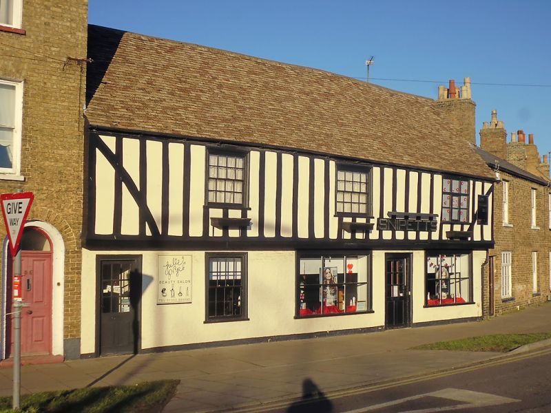
EXTERIOR: the principal frontage to St Mary’s Street is of three-bays and two-storeys, forming a continuous C16 jettied structure within a terrace of buildings at the junction with West End. All of the external evidence for the earliest phase of the building is currently (2016) obscured by an affixed board frontage at first-floor level, which has mock timber framing painted on. Three windows are positioned off-set to the right side of the façade; the first two being C18 8 over 8 sash windows and the last, at the far right, being a C20 casement type. At ground-floor level the front wall was rebuilt in brick in the C18 to create a fashionable straight façade although here the jetty was retained. At street level there is a part-glazed C19 door at the far left side of the façade with a further C18 8 over 8 sash window positioned adjacent. On the right-hand side of the frontage there is a pair of C20 glazing-bar shop windows flanking a matching C19 door.
The rear portion of the St Mary’s Street range has a roofline which sweeps down to the ground floor level. At the north-east side of the main range is a cross wing dating from the first half of the C19, this hipped with the roof pitch of the main range, although slightly lower in height. Along the northern side of the C16 range is a later C19 single-storey projection which appears to be contemporary with the single-storey pitched extension to the cross wing, probably late C19. All of the windows and doors in this rear portion of the building are later C20 replacements and there is no extant evidence of fabric from the earliest phases of construction visible in this portion of the building.
INTERIOR: at ground-floor level of the main St Mary’s Street range the majority of early partitions have been removed to create a large undivided space. The principal surviving evidence for the first C16 phase is in the form of the ceiling, in which the two and half bays of the original building are defined by three cross rails, all with the same stepped chamfered stops. The western cross rail is largely obscured by the later stair inserted into the narrow western bay, this being distinct from the rest of the ground floor and accessed via the separate west entrance door. The eastern two cross rails have more visible evidence remaining. The central one is chamfered and stopped for the position of the spine beams in the bays to either side. Towards its northern end there is a redundant mortice for an original post, almost certainly indicating the position of an internal doorway between the two original full bays. This suggests that the two bays were originally partitioned, although currently the studding is a C20 addition possibly incorporating early timbers from elsewhere in the building. The doorway appears to have sat against the north wall of the building, with the other jamb presumably originally formed by the principal post, although this has been removed and C20 posts and bracing now provide additional structural support in this opened-out space.
The third cross rail (that furthest east) is chamfered on its western side and stopped for the spine beam, but not chamfered on its eastern side. This lack of chamfer is one piece of evidence for the slightly later C16 date of the eastern bay. On the underside of the beam is a large residual groove probably allowing for a plank partition. The groove terminates adjacent to a redundant mortice on the underside of the beam, and the chamfer on the western side stops adjacent to the same feature. This is in-line with the redundant mortice on the cross rail immediately to the west, and probably represents another original door position, although this door would have been an external rather than internal feature (at least prior to the later C16 single-bay extension to the east). The two spine beams between the original cross rails are both chamfered but the one in the eastern bay is more elaborately moulded than those further west; this featuring ogee and hollow roll moulding which terminates at the western end in run out stops. This distinction in the treatment of the spine beam moulding offers further evidence of a separate phase of construction of this eastern bay. Any additional evidence for the gable end of this bay has been lost through the truncation of the eastern wall.
During C18 the front wall at ground-floor was replaced with later brickwork, although part of the mid-rail in the second bay survives. This has a recess centrally placed within the bay, indicating the position of shutters for an original window opening. The retention of this portion of the mid-rail demonstrates the position of the original front wall St Mary’s Street frontage and shows that the C18 brick reconstruction broadly followed the same line as the C16 one it replaced.
At first-floor level of the main St Mary’s Street range, the extant evidence suggests the original building comprised a two-bay, single-room plan, with a smoke bay at the western end (now occupied by the enclosed staircase). The bays can still be read in the set of surviving jowled posts and the tie beams in this part of the building. Beginning at the western side, the first truss (that of the end wall) is concealed by later plasterwork, but the posts and tie beam of the truss between the narrow western bay and the first full bay survive intact. The tie beam here has residual peg positions for a closed partition below the tie beam indicating that the narrow bay (the present staircase) was subdivided from the rest of the building. At its northern end, where it is now open for the doorway for the stairwell, a residual mortice position is also visible (possibly for a rising brace). Set into the north wall, just to the east of the second tie beam, there is a pair of mullions set diamond-wise in the frame which would have formed an original three-light window. Above the tie beam here the original studding appears to indicate that the bay was also closed at this level. There is no surviving evidence for any fireplace position at upper level within this wall.
Of the third truss from the west it is only the jowled posts and tie beam which survive. These are chamfered on both sides, indicating that it has always formed an intermediate truss. Curved braces rise from the posts to the tie beam. These are not chamfered, but their presence suggests that the truss was originally open, allowing for a large undivided, two-bay space at first-floor level. Above the tie beam the original timbers do not survive, although there is no evidence for former partitioning on this alignment. The fourth truss appears to have always formed a further closed truss – originally acting as the eastern end of the building. The eastern side of the truss (seen from the separate later C16 bay) is concealed by applied timbers, but to the west some parts of the original tie beam and jowled posts remain visible. The tie beam is slightly cambered and has a series of pegs on its lower edge indicating the position of studding for a closed partition. The extant studding closing this bay may represent this original partition, although this cannot be identified with any certainty.
Other evidence of the earliest C16 phase which remains visible at first-floor level is the front (south) wall plate. This is chamfered and stopped where it meets the trusses, with a simple straight stop. Towards the eastern end, close to the fourth truss there is an edge halved and bridled scarf joint. The principal feature of the wall plate is that in both of the two full bays it has a recess cut into its lower edge, indicting the position of window shutters, and the position of windows in each bay in addition to the window set into the north wall. The window position in the western full bay is set slightly west of centre, that in the eastern bay is positioned slightly to the east of centre.
In the later C16 eastern bay of the upper-floor, which is entirely closed-off from the western side of the range, the front (south) wall plate survives intact. That to the rear, has been removed to accommodate the addition of the C19 rear wing. A rebate cut into the lower edge of the wall plate indicates the position of shutters for a large window opening, centrally placed in the bay. The eastern truss has two jowled posts rising in the corners. The jowls only extend against the eastern half of the post, with the western section of the post rising straight up, presumably because it forms the corner of the building. The tie beam is straight, with the stud work of the eastern elevation visible below, this pegged into the tie beam at their upper edges. Above the tie beam three studs for a closed truss are visible in the centre, these being pegged to the tie beam. The remainder of the truss here is concealed.
Above the tie beams in the C16 St Mary’s Street range of the building (including the later C16 eastern bay) the roof structure has seen much alteration. The changes here, thought to be principally undertaken in the C17, saw the removal of many of the original roof timbers above tie beam level along with any earlier ceiling which may have existed. The original roof structure was replaced with a disparate set of timbers, most of them reused, which now provide raking struts to support the purlins in the intermediate open truss. Reused timbers, including a large section of what appears to be an original wall plate, were also used to form spine beams in the bays at first-floor level. It is probable that this formed part of a ceiling in process, whereby the first-floor was closed at tie beam level, a development typical of the C17.
The rear wing, which is an addition of the C19 (pre-1843 on the basis of map evidence), retains no original visible structural members or fittings at either ground- or first-floor level, therefore making it difficult to ascribe a more precise date with any certainty. The single-storey pitched extension to the cross wing along with the extension along the north side of the main range are probably later additions of the C19, though again no internal features of this date appear to survive in either of these areas to date these more accurately.
The present city of Ely rises 20m above the surrounding fen on an island of Kimmeridge clay. Although well connected by river and waterways, until the C17 only causeways connected the island to the mainland, and in the early years of Christianity its isolation made it an ideal refuge for those seeking a secluded monastic life. The first successful attempt to establish a religious settlement here was made by Etheldreda in c.673, re-endowed by King Edgar 100 years after its destruction by the Danes in 870. Despite threats of further invasion in the C11, and later political turmoil, this monastery survived until its dissolution in 1539. The presence of a monastic community occupying substantial buildings required the support of a lay community, and as that grew, so did the needs of the lay-people for accommodation and services. A detailed survey of 1416 recorded 457 buildings and described an established street pattern; by 1563 the number of households had grown to 800. Despite this growth in population, John Speed’s map of Ely, published in 1611/12, is very similar in both layout and extent to that of the first edition Ordnance Survey (OS) Map of 1885, where the only significant expansion is towards the railway (1845): however, in Speed’s map, houses lining the streets enclose spaces of apparently horticultural and even agricultural production, and while these are still present on the 1885 map they have been pushed to the margins of the city. These maps graphically illustrate the continuing importance of agriculture and agriculturally related industries in the early C17 and beyond, and also show that the later growth in population took place mainly within the confines of the early city street plan. Before the later C19, the only significant rival to agriculture was the pottery industry, in production from the C12 to 1860.
Following the dissolution of the monastery, Ely remained the centre of the diocese, but the loss of the community, and of pilgrims to the shrine of St Etheldreda, would have had a considerable impact on the city’s economy. The consequent decline in management of the fen and its waterways led to an increase in flooding, and attempts at drainage in the C17 and C18 seem to have had limited effect, creating constraints on the ability of the city to thrive. Successive literary travellers commented on the poor drainage, including Celia Fiennes in the mid-C17, who described the city as a “perfect quagmire”, and Daniel Defoe in the early C18, who noted both the city’s market gardens and its overflowing wells. By the mid-C19 the city was in a state of recovery and regeneration: several possible contributory factors include successful drainage, enclosure (1848) and the arrival of the railway with the opening of the Cambridge to Ely line in 1845. This was followed slightly later by other lines, making the city a transport hub. Despite this, the physical expansion of Ely beyond its medieval core was slow through the mid-C20, accelerating through the late C20 and into the C21, as Ely developed as a dormitory town for Cambridge.
The building considered here, at 82 and 84 St Mary’s Street occupies a continuous terrace of buildings along the north side of the street at the junction with West End. St Mary’s Street is the main route to the city from Cambridge and the south and west, and in the medieval period formed one of the principal approaches by land to the city, negotiating the fens via the causeway at Aldreth. To the south of the West End junction the street broadens out into a small green, known as St Mary’s Green, which marks the western tip of the open area to the west of the cathedral known as Palace Green. Originally this area was larger, extending to St Mary’s Street to the north, where properties have now been built fronting onto the street.
To the south of St Mary’s Green is St Mary’s Church, the parish church in Ely, and one of two in use in the medieval period. Despite some commercial activity on St Mary’s Street the area was removed from the main market square, and from the trading area by the river. Its focus appears instead to have been on the religious and institutional side of the city’s life. By the late medieval period the bishop’s palace sat immediately south of palace green and as well as St Mary’s Church and its associated vicarage (now Oliver Cromwell’s house) there was also a large tithe barn, and, further west, the hospital of St Mary Magdalene and St John’s. In addition there appear to have been a number of early guilds in the area, with at least two known to have had halls within close proximity to the parish church. By the late medieval period the land on St Mary’s Street was principally in the ownership of the bishop or the prior. In the 1417 survey of Ely a continuous run of tenements from the corner of St Mary’s Street and Downham Road (known as Mepsale’s Corner) to St John’s Hospital (Holton Krayenbuhl 2011, 133; 135). This suggests that the street was largely built up by the early c15, if not before.
The earliest evidence visible in the standing building at 82 and 84 St Mary’s Street is for a C16 continuous-jetty building running parallel to the street front. In its original form it is suggested that the building had a smoke bay at the western end, probably with an associated entrance and stair, and two rooms at ground- and first-floor level, though much of the external evidence for this phase is obscured. In what appears to be a secondary C16 phase, an additional eastern bay was added, this slightly wider than the full bays to the west. A later significant set of alterations to the building cannot be precisely dated, but have been loosely ascribed to the C17. This phase principally involved the reconfiguration of the roof, with the building being ceiled over at tie beam level on the first floor and the structure above being largely rebuilt with a disparate set of timbers, many reused. Into the C18 the front wall of the ground-floor portion of the building was rebuilt in brick, though unusually for the period the jettied profile remained. The cross wing which runs north of the building at its eastern end was probably added in the first half of the C19, certainly prior to 1843 as it is shown on the Tithe map of Ely of that year, although the extension along the north of the main range and at the end of the cross wing are probably later C19 additions. Into the C20 the main changes relate to the reopening of spaces within the building, including the removal of partitions at ground-floor level to create a large open space.
In the original 1968 List entry for 82 and 84 St Mary’s Street, it was described as: ‘an early Cl7 timber-framed and plastered building with later alterations. 2 storeys. The 1st storey, which was originally jettied, has a slight overhang and the ground storey has been built out in brick. 3 window range, C20 easements and 1 C18 double-hung sash window with glazing bays. The ground storey has C19 and C20 shop fronts. The interior of No 82, on the ground storey, has moulded beams and joists. Roof tiled, now covered with cement slurry'.
82 and 84 St Mary’s Street is listed at Grade II for the following principal reasons:
* Architectural interest: as a building with C16 origins and a range of subsequent phases covering four centuries. Surviving fabric and structural detail from each phase reflects the changing needs of succeeding occupants, thus providing important evidence for historic building traditions;
* Historic interest: it lies within the area of settlement described on John Speed’s map of 1610/1611, a street pattern established by the early C15, and makes an important contribution to the historical development of the townscape;
* Group value: it lies within the Ely Conservation Area, and is one of 198 listed buildings in the city, thus forming part of a collection which illustrates building traditions spanning several centuries.
External links are from the relevant listing authority and, where applicable, Wikidata. Wikidata IDs may be related buildings as well as this specific building. If you want to add or update a link, you will need to do so by editing the Wikidata entry.


Other nearby listed buildings
