Approximate Location Map
Large Map »
Latitude: 52.3996 / 52°23'58"N
Longitude: 0.2663 / 0°15'58"E
OS Eastings: 554285
OS Northings: 280368
OS Grid: TL542803
Mapcode National: GBR M6H.G57
Mapcode Global: VHHJ6.KYNC
Plus Code: 9F4297X8+RG
Entry Name: 5 Market Place
Listing Date: 19 June 1972
Last Amended: 18 November 2016
Grade: II
Source: Historic England
Source ID: 1331717
English Heritage Legacy ID: 48757
ID on this website: 101331717
Location: Ely, East Cambridgeshire, CB7
County: Cambridgeshire
District: East Cambridgeshire
Civil Parish: Ely
Built-Up Area: Ely
Traditional County: Cambridgeshire
Lieutenancy Area (Ceremonial County): Cambridgeshire
Church of England Parish: Ely
Church of England Diocese: Ely
Tagged with: Building
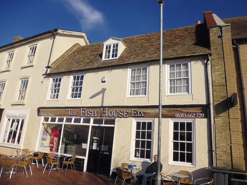
House of probable late C16 origin, altered in the C17 and C18, refronted in the early C19, and altered in the C20.
House of probable late-C16 origin, altered in the C17 and C18, refronted in the early C19, and altered in the C20.
MATERIALS: rendered timber framing, brick frontage (painted), and roof covering of plain clay tiles of various hues.
PLAN: the building is part of a terrace and consists of a front range facing south-west which runs parallel to the market place, and a rear range at right angles to the north-east. Built in the east angle formed by these ranges is an C18 wing. There is an open yard to the rear (north-east) with a two-storey range, possibly of late-C18 or early-C19 date, which is attached to a range of late-C19 outbuildings along the south-east side. These are linked to the main ranges by a mid/ late-C20 extension.
EXTERIOR: the two-storey, five-bay front elevation has a pitched roof with a parapet at the north-west gable and a central, gabled, dormer window with timber casements wholly in the roof space. The ground floor has a central front door and associated large plate glass window with tiled stall riser in the two bays to the left, all of C20 date. The two bays to the right are lit by early-C19 nine-over-nine pane sash windows in moulded frames. The first floor is lit by four similar windows in bays one, two, four and five which appear to have been shortened. Between the two storeys is a fascia bearing the name of the shop.
The north-east range has a steeply pitched, tile-clad roof. The gable end is lit on the ground floor by a two-light casement window, and a fire escape leads up to the glazed door on the first floor which has a large two-pane window on the right. In the gable head the slight projection of a collar beam is visible under the render. The jettied north-west side has a rebuilt brick ground floor which supports the projecting joists of the jetty.
To the left of the north-east range, the C18 brick wing has a steeply pitched roof and is lit on the first floor by an C18 six-over-six pane sash in a moulded frame. The ground floor has been subsumed by a flat-roofed C20 extension.
INTERIOR: the front range has two rooms on each floor and in the attic, with a central passage running through the ground floor to the rear range. The room to the left (north-west) has modern fittings for frying fish and chips. The room to the right (south-east) has C18 square panelling to dado height with a projecting dado rail, panelled embrasures, and a moulded and dentilled cornice. It has a blocked fireplace with a two-panelled cupboard door on the left with HL hinges. On the first floor of the front range, the south-east room has a chamfered spine beam with stops, an C18 two-panelled door with HL hinges, panelled window jambs, and a 1950s tiled corner fireplace. The south section of a cambered tie beam is just visible in the south corner of the room, indicating the original south-eastern end of the building, and in the partition between the two rooms are visible the north and south ends of a further cambered tie beam. The south-west room has a boxed-in spine beam, panelled window jambs, a two-panelled door with L-hinges, and a cupboard with a two-panelled door with L-hinges in which is fitted a C19 desk with drawers. The two attic rooms both have wide floorboards. Underneath those in the south-west room is a cambered tie beam, the higher section of which is exposed. Projecting eastwards, within the floor, is a spine beam with a series of joists. This room has a plank and batten door with strap hinges and a small cupboard with two sections of borrowed lights forming the upper part of the two sides. These sections are formed of a series of splat balusters which may be reused from elsewhere in the building. Between the two attic rooms is a C17 elaborately moulded plank and batten door with a door handle and decorative back plate.
A large chimney breast rises through the building between the front and rear range. The southern part may date to the late C16 phase, and it was then expanded to heat the later C17 range. In the rear (south-east) range the ground-floor room has an exposed moulded spine beam. The room has recently (2014/15) been clad in horizontal timber panels and plastered over but underneath three sides of the room retain C18 panelling. This is described in the Historic England survey report (2014) as surviving with some alteration up to a dado rail with large fielded panels graduating in size with larger panels at the bottom. To the south-east of this room the C20 straight flight of stairs retains part of an C18 pendant of a newel belonging to the earlier stair. The section of splat balustrading is imitation work. The first-floor room of the rear range has a boxed in bridging beam and retains two two-panelled doors, one to a cupboard. At the top of the stairs from the first floor to the attic is a small section of C17 balustrade consisting of splat balusters and faceted newels which has been repositioned from elsewhere in the house. The attic of the rear range has exposed wall plates, which now sit at an intermediate height, with some studs. The roof structure is concealed by plaster so it is not possible to identify any indications of the original truss form.
The C18 rear extension has been converted to a kitchen at ground-floor level. The first-floor room has a large corner fireplace (now boarded) with an ogee moulded mantel shelf, a panelled overmantel, and to the right-hand side a series of small cupboards placed as a column running up the side of the hearth.
SUBSIDIARY FEATURES: the series of late-C19, single-storey outbuildings along the south-east side of the plot are constructed of brick, painted overall, with pitched pantile-clad roofs. They are lit by C20 windows and provide storage and lavatory facilities. Attached to the north-west side of this range is a two-storey block occupying the north-east end of the plot. This has been heavily altered but has a cogged eaves course suggestive of an early-C19 date. It is constructed of brick, painted overall, with a pitched pantile-clad roof and brick ridge stack on the right gable end. There is a bricked up doorway on the left, an off-centre door and a C20 window, with two C20 windows above. Internally, the ground floor contains a large C19 fireplace with the remains of a cooking range.
The present city of Ely rises 20m above the surrounding fen on an island of Kimmeridge clay. Although well connected by river and waterways, until the C17 only causeways connected the island to the mainland, and in the early years of Christianity its isolation made it an ideal refuge for those seeking a secluded monastic life. The first successful attempt to establish a religious settlement here was made by Etheldreda in c.673, re-endowed by King Edgar 100 years after its destruction by the Danes in 870. Despite threats of further invasion in the C11, and later political turmoil, this monastery survived until its dissolution in 1539. The presence of a monastic community occupying substantial buildings required the support of a lay community, and as that grew, so did the needs of the lay-people for accommodation and services. A detailed survey of 1416 recorded 457 buildings and described an established street pattern; by 1563 the number of households had grown to 800. Despite this growth in population, John Speed’s map of Ely, published in 1611/12, is very similar in both layout and extent to that of the first edition Ordnance Survey (OS) Map of 1885, where the only significant expansion is towards the railway (1845): however, in Speed’s map, houses lining the streets enclose spaces of apparently horticultural and even agricultural production, and while these are still present on the 1885 map they have been pushed to the margins of the city. These maps graphically illustrate the continuing importance of agriculture and agriculturally related industries in the early C17 and beyond, and also show that the later growth in population took place mainly within the confines of the early city street plan. Before the later C19, the only significant rival to agriculture was the pottery industry, in production from the C12 to 1860.
Following the dissolution of the monastery, Ely remained the centre of the diocese, but the loss of the community, and of pilgrims to the shrine of St Etheldreda, would have had a considerable impact on the city’s economy. The consequent decline in management of the fen and its waterways led to an increase in flooding, and attempts at drainage in the C17 and C18 seem to have had limited effect, creating constraints on the ability of the city to thrive. Successive literary travellers commented on the poor drainage, including Celia Fiennes in the mid-C17, who described the city as a “perfect quagmire”, and Daniel Defoe in the early C18, who noted both the city’s market gardens and its overflowing wells. By the mid-C19 the city was in a state of recovery and regeneration: several possible contributory factors include successful drainage, enclosure (1848) and the arrival of the railway with the opening of the Cambridge to Ely line in 1845. This was followed slightly later by other lines, making the city a transport hub. Despite this, the physical expansion of Ely beyond its medieval core was slow through the mid-C20, accelerating through the late C20 and into the C21, as Ely developed as a dormitory town for Cambridge.
5 Market Place is part of a continuous terrace of buildings situated to the north of Ely’s market square. As originally laid out the square was considerably larger, extending westwards from the current open area. Properties may well have been laid out along the sides of the market place as part of the suggested C12 planning of the city. The process of infilling appears to have begun by the medieval period which must have left properties around the surviving open section of the square particularly prominent in the late medieval and post-medieval periods. At the time of the 1416/17 survey the site of 5 Market Place was part of a tenement owned by the Prior and in the hands of Nicholas Wace ‘lying between the said tenement of J. Swan that is of the lord bishop’s fee on the east and a tenement of John Cut the butcher on the west, it contains in front towards the said common market 2 perches less ½ iron yard’ (Holton Krayenbuhl 2011, 113). The prominent market place plots were, unsurprisingly, being used for trade, although there is no indication of whether the tenant of the plot on the site of 5 Market Place was trading.
The earliest phase now identifiable in the building is that of a probable late C16 two-bay, two-storey range, probably timber framed, running parallel to the street frontage. This has been heavily altered, particularly at ground-floor level, and much of its plan form and function is unclear. The principal evidence is the north post and tie beam of what was the north-western end of the building with an associated spine beam and joists. This end truss sits c.1m in from the western side of the plot which shows that there was originally an alleyway leading from the market square to the rear of the building. The upper floor was later extended, possibly in the early C19, to appropriate the area over the alleyway. The south-eastern extent of the original building is indicated by the southern section of a tie beam. It is likely that the large chimney stack also dates to this period. The jettied two-bay timber framed range at the rear may have been contemporary with the front range or may have been built soon after in the early C17. It has also been subject to considerable alterations which make its original form and function very difficult to establish but it seems likely that it originally provided a single large room on each of the three levels.
A two-storey extension was built against the eastern side of the north-east range in the C18, and other internal changes took place in this period, including the panelling of some of the rooms. In the early C19 the façade was refronted in brick. An early C20 photograph shows that it had a central entrance with a pedimented doorcase flanked by a pair of windows, the eastern pair of which still survives. The attic was lit by a pair of dormers. This arrangement did not make any specific provision for commercial or trade premises and it may be that the updating of the façade reflected a change of use to domestic or possibly business premises. Around the same time, the western wall of the timber-framed ground floor of the north-east wing was rebuilt in brick. The two-storey detached block at the northern end of the plot also belongs to this phase. It contains a large C19 fireplace, probably for cooking, suggesting that this building was intended to provide service accommodation for the main building.
In the second half of the C20 a plate glass window and associated doorway was inserted in the south elevation, and a flat roofed extension built in the angle of the main range and north-east wing, linking the main building to the outbuildings along the eastern side of the plot. The north-east gable of the north-east range was reconstructed and the first-floor room appears to have been altered for use as a public dining room, including the provision of a new window and fire escape. It may have been at this point that the stair was altered, with a modern straight flight inserted (presumably to ease public access) and a dormer window inserted at attic level on the south-eastern side. 5 Market Place has functioned as a fried fish bar since at least 1951.
5 Market Place, a house of probable late-C16 origin, later altered and extended, is listed at Grade II for the following principal reasons:
* Architectural interest: it has evolved over four centuries, reflecting the changing needs of succeeding occupants and retaining significant fabric and structural detail from each phase, thus providing important evidence for historic building traditions;
* Historic interest: it lies within the area of settlement depicted on John Speed’s map of 1610/1611, a street pattern established by the early C15, and makes an important contribution to the understanding of the historical development of the townscape;
* Group value: it is one of 198 listed buildings in the city illustrating building traditions spanning several centuries, out of which it has particular group value with nos. 1, 3 and 11 Market Place.
External links are from the relevant listing authority and, where applicable, Wikidata. Wikidata IDs may be related buildings as well as this specific building. If you want to add or update a link, you will need to do so by editing the Wikidata entry.


Other nearby listed buildings
