Approximate Location Map
Large Map »
Latitude: 52.2082 / 52°12'29"N
Longitude: 0.1184 / 0°7'6"E
OS Eastings: 544845
OS Northings: 258775
OS Grid: TL448587
Mapcode National: GBR L79.DRV
Mapcode Global: VHHK3.0RFL
Plus Code: 9F426459+79
Entry Name: 14 and 15, St John's Street
Listing Date: 2 November 1972
Grade: II
Source: Historic England
Source ID: 1331918
English Heritage Legacy ID: 47758
ID on this website: 101331918
Location: Cambridge, Cambridgeshire, CB2
County: Cambridgeshire
District: Cambridge
Electoral Ward/Division: Market
Parish: Non Civil Parish
Built-Up Area: Cambridge
Traditional County: Cambridgeshire
Lieutenancy Area (Ceremonial County): Cambridgeshire
Church of England Parish: Cambridge St Andrew the Great
Church of England Diocese: Ely
Tagged with: Building
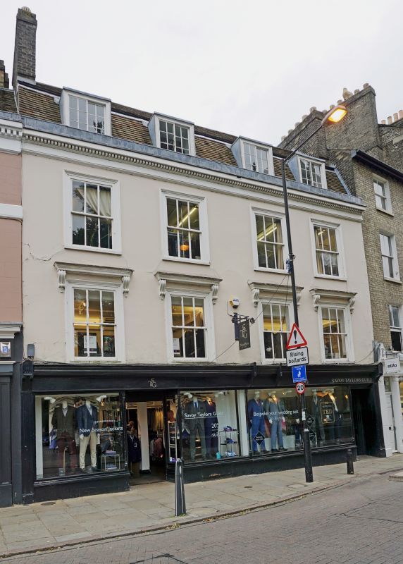
ST J0HN's STREET
1.
942
(East Side)
Nos 14 and 15
TL 4458 NE 3/657
II GV
2.
C18. Timber-framed, rendered and painted. 3 storeys and attic, 4 windows
to pair Cl9 sashes with stucco architraves, the first floor windows have
bracketted hoods; 4 attic dormers. Modern shopfront. Timber dentil eaves
cornice, tiled mansard roof.
Nos 11 to 17 (consec) and Nos 63 to 65 (consec) Bridge Street form a group,
important particularly as closing Bridge Street on the South.
Listing NGR: TL4484558775
External links are from the relevant listing authority and, where applicable, Wikidata. Wikidata IDs may be related buildings as well as this specific building. If you want to add or update a link, you will need to do so by editing the Wikidata entry.


Other nearby listed buildings
