Approximate Location Map
Large Map »
Latitude: 51.5033 / 51°30'11"N
Longitude: -0.6617 / 0°39'42"W
OS Eastings: 492982
OS Northings: 179114
OS Grid: SU929791
Mapcode National: GBR F84.MHZ
Mapcode Global: VHFT7.HG0X
Plus Code: 9C3XG83Q+88
Entry Name: Garden Wall to Prior's Croft
Listing Date: 26 April 1985
Grade: II
Source: Historic England
Source ID: 1332698
English Heritage Legacy ID: 44037
ID on this website: 101332698
Location: Dorney, Buckinghamshire, SL4
County: Buckinghamshire
Civil Parish: Dorney
Built-Up Area: Dorney
Traditional County: Buckinghamshire
Lieutenancy Area (Ceremonial County): Buckinghamshire
Church of England Parish: Dorney
Church of England Diocese: Oxford
Tagged with: Wall
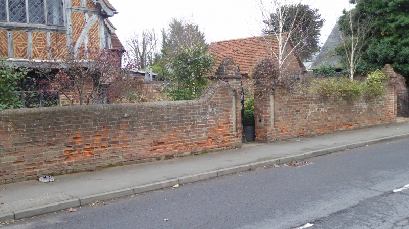
SU 9279 DORNEY VILLAGE ROAD (north side)
21/434 Garden wall to Prior's
Croft
-
GV II
C19. Red brick and curved to extra height at gate openings. Restored gate
piers with brick pyramid tops. Modern gates.
Listing NGR: SU9298279114
External links are from the relevant listing authority and, where applicable, Wikidata. Wikidata IDs may be related buildings as well as this specific building. If you want to add or update a link, you will need to do so by editing the Wikidata entry.


Other nearby listed buildings
