Approximate Location Map
Large Map »
Latitude: 51.7742 / 51°46'27"N
Longitude: -0.928 / 0°55'40"W
OS Eastings: 474059
OS Northings: 208934
OS Grid: SP740089
Mapcode National: GBR C1V.L7C
Mapcode Global: VHDV8.VNRS
Plus Code: 9C3XQ3FC+MQ
Entry Name: 6, Fern Lane
Listing Date: 11 October 1985
Grade: II
Source: Historic England
Source ID: 1332942
English Heritage Legacy ID: 43159
ID on this website: 101332942
Location: Fort End, Buckinghamshire, HP17
County: Buckinghamshire
Civil Parish: Haddenham
Built-Up Area: Haddenham
Traditional County: Buckinghamshire
Lieutenancy Area (Ceremonial County): Buckinghamshire
Church of England Parish: Haddenham
Church of England Diocese: Oxford
Tagged with: Building Thatched cottage
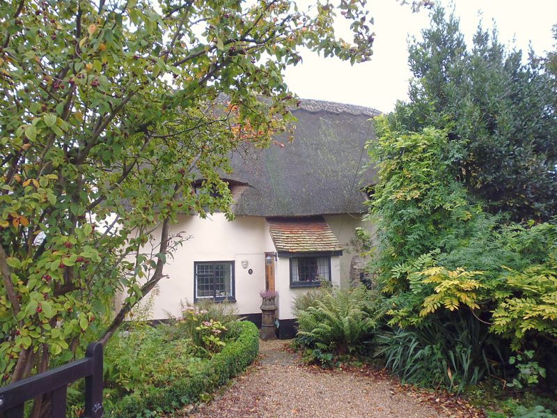
SP 7408 HADDENHAM FERN LANE
(east side)
11/218 No.6.
-
GV II
Cottage. C17. Witchert, on a rubblestone plinth, all colourwashed
and rendered. Thatched roof, half-hipped to left. 2 bays and 1½ storeys.
Central door in lean-to tile roofed modern porch. 2-light casements, the
upper as eaves dormers. Central stack forming lobby entry plan type.
RCHM I. 183. MON.40.
Listing NGR: SP7405908936
External links are from the relevant listing authority and, where applicable, Wikidata. Wikidata IDs may be related buildings as well as this specific building. If you want to add or update a link, you will need to do so by editing the Wikidata entry.


Other nearby listed buildings
