Approximate Location Map
Large Map »
Latitude: 50.5814 / 50°34'52"N
Longitude: -3.4699 / 3°28'11"W
OS Eastings: 296028
OS Northings: 76767
OS Grid: SX960767
Mapcode National: GBR P2.RBG0
Mapcode Global: FRA 37MJ.G0Y
Plus Code: 9C2RHGJJ+G2
Entry Name: United Reformed Church
Listing Date: 21 March 1985
Grade: II
Source: Historic England
Source ID: 1334503
English Heritage Legacy ID: 84424
ID on this website: 101334503
Location: Dawlish, Teignbridge, Devon, EX7
County: Devon
District: Teignbridge
Civil Parish: Dawlish
Built-Up Area: Dawlish
Traditional County: Devon
Lieutenancy Area (Ceremonial County): Devon
Church of England Parish: Dawlish St Gregory
Church of England Diocese: Exeter
Tagged with: Church building
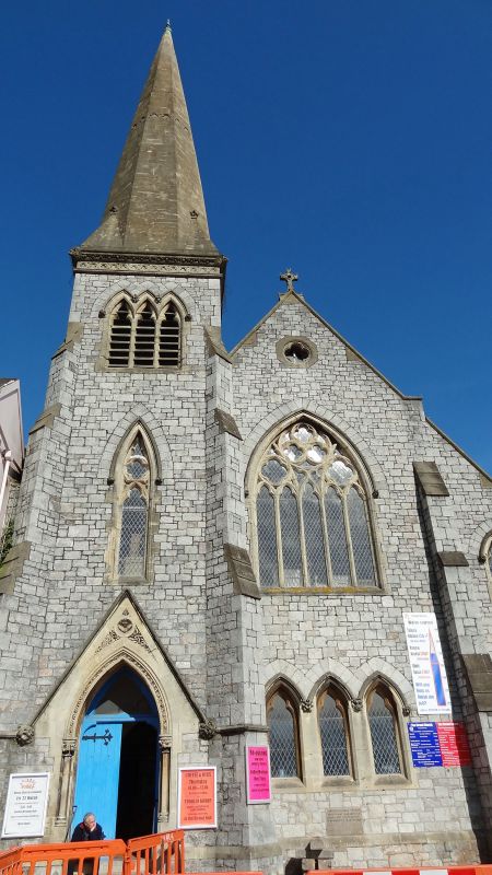
SX 9676 DAWLISH THE STRAND
8/103 No 32
(United Reformed Church)
-
GV II
Dated 1870. Built of coursed rubble with gable to front. North west
tower surmounted by spire. Included as a landmarkand for group value.
Listing NGR: SX9602876767
External links are from the relevant listing authority and, where applicable, Wikidata. Wikidata IDs may be related buildings as well as this specific building. If you want to add or update a link, you will need to do so by editing the Wikidata entry.


Other nearby listed buildings
