Approximate Location Map
Large Map »
Latitude: 53.2887 / 53°17'19"N
Longitude: -1.6878 / 1°41'16"W
OS Eastings: 420907
OS Northings: 376903
OS Grid: SK209769
Mapcode National: GBR JZND.DT
Mapcode Global: WHCCV.1LKP
Plus Code: 9C5W78Q6+FV
Entry Name: Gatepiers Between Eyam House and Eyam View Farmhouse
Listing Date: 12 October 1984
Grade: II
Source: Historic England
Source ID: 1334916
English Heritage Legacy ID: 80656
ID on this website: 101334916
Location: Derbyshire Dales, Derbyshire, S32
County: Derbyshire
District: Derbyshire Dales
Civil Parish: Eyam
Traditional County: Derbyshire
Lieutenancy Area (Ceremonial County): Derbyshire
Church of England Parish: Eyam St Lawrence
Church of England Diocese: Derby
Tagged with: Gatepost
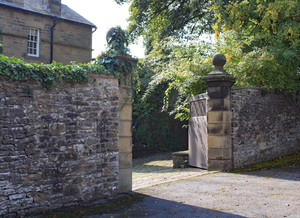
SK 27 NW PARISH OF EYAM EYAM ROAD
4/48 (South Side)
Gatepiers between Eyam House
and Eyam View Farmhouse
GV II
Gatepiers. Early C19. Gritstone. Eight feet high, square, rusticated gatepiers
with moulded cornices and ball finials. Included for group value only.
Listing NGR: SK2090776903
External links are from the relevant listing authority and, where applicable, Wikidata. Wikidata IDs may be related buildings as well as this specific building. If you want to add or update a link, you will need to do so by editing the Wikidata entry.


Other nearby listed buildings
