Approximate Location Map
Large Map »
Latitude: 52.9773 / 52°58'38"N
Longitude: -1.6959 / 1°41'45"W
OS Eastings: 420514
OS Northings: 342262
OS Grid: SK205422
Mapcode National: GBR 49B.B1X
Mapcode Global: WHCFC.XFLC
Plus Code: 9C4WX8G3+WJ
Entry Name: Dam and Waterwheel
Listing Date: 12 July 1985
Grade: II
Source: Historic England
Source ID: 1335069
English Heritage Legacy ID: 81413
ID on this website: 101335069
Location: Derbyshire Dales, Derbyshire, DE6
County: Derbyshire
District: Derbyshire Dales
Civil Parish: Osmaston
Traditional County: Derbyshire
Lieutenancy Area (Ceremonial County): Derbyshire
Church of England Parish: Osmaston St Martin
Church of England Diocese: Derby
Tagged with: Dam Water wheel
SK 24 SW
5/72
PARISH OF OSMASTON
OFF LIME AVENUE
(South Side)
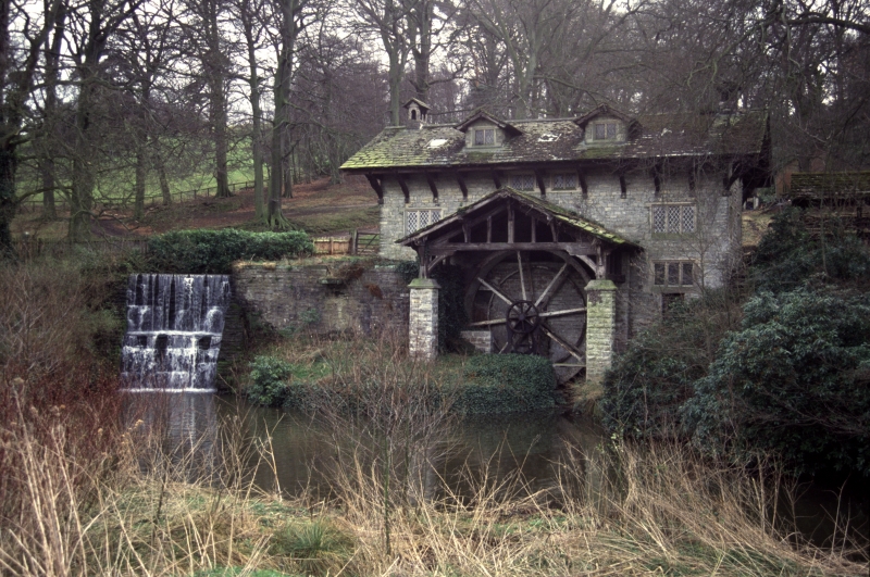
Dam and Waterwheel
II
Dam and waterwheel at south end of main lake. Late 1840s by Stevens of Derby. Coursed
squared rock faced limestone. Embankment dam of curved plan, the walls with a slight
batter. Footpath along the top with stone steps descending on the curved walls on
each side. Plain iron railings. Waterwheel with overshoot, attached to a wooden hut
with corrugated iron and stone slate roof. The hut houses a pumping engine still in
situ.
Listing NGR: SK2051442262
External links are from the relevant listing authority and, where applicable, Wikidata. Wikidata IDs may be related buildings as well as this specific building. If you want to add or update a link, you will need to do so by editing the Wikidata entry.


Other nearby listed buildings
