Approximate Location Map
Large Map »
Latitude: 53.0179 / 53°1'4"N
Longitude: -1.7331 / 1°43'59"W
OS Eastings: 418000
OS Northings: 346763
OS Grid: SK180467
Mapcode National: GBR 48Q.SRC
Mapcode Global: WHCF5.BDYS
Plus Code: 9C5W2798+4Q
Entry Name: 29, Market Place
Listing Date: 14 February 1974
Grade: II
Source: Historic England
Source ID: 1335128
English Heritage Legacy ID: 79882
ID on this website: 101335128
Location: Ashbourne, Derbyshire Dales, Derbyshire, DE6
County: Derbyshire
District: Derbyshire Dales
Civil Parish: Ashbourne
Built-Up Area: Ashbourne
Traditional County: Derbyshire
Lieutenancy Area (Ceremonial County): Derbyshire
Church of England Parish: Ashbourne St Oswald
Church of England Diocese: Derby
Tagged with: Building
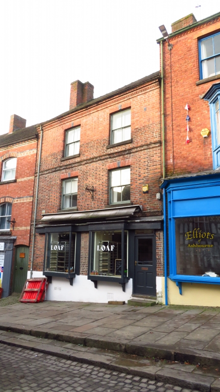
MARKET PLACE
1.
783
(West Side )
No 29
SK 14 NE 1/153
II GV
2.
Mid C19. Red brick with tiled roofs, brick band at 1st and 2nd floor sill heights.
3 storeys, 2 windows without glazing bars, with small keystones. 2 small modern
square bays forming shop windows. Grade II for group value.
All the listed buildings in Market Place form a group.
Listing NGR: SK1800246762
External links are from the relevant listing authority and, where applicable, Wikidata. Wikidata IDs may be related buildings as well as this specific building. If you want to add or update a link, you will need to do so by editing the Wikidata entry.


Other nearby listed buildings
