Latitude: 53.0568 / 53°3'24"N
Longitude: -1.3704 / 1°22'13"W
OS Eastings: 442294
OS Northings: 351243
OS Grid: SK422512
Mapcode National: GBR 7DS.8CX
Mapcode Global: WHDG8.XFLG
Plus Code: 9C5W3J4H+PR
Entry Name: Former Newlands Inn
Listing Date: 25 May 1988
Grade: II
Source: Historic England
Source ID: 1335396
English Heritage Legacy ID: 79099
ID on this website: 101335396
Location: Golden Valley, Amber Valley, Derbyshire, DE55
County: Derbyshire
District: Amber Valley
Electoral Ward/Division: Ironville and Riddings
Parish: Non Civil Parish
Traditional County: Derbyshire
Lieutenancy Area (Ceremonial County): Derbyshire
Church of England Parish: Ironville Christ Church
Church of England Diocese: Derby
Tagged with: Inn
This list entry was subject to a Minor Amendment on 9 February 2022 to update the name and address and to reformat the text to current standards
SK 45 SW
4/55
RIDDINGS
NEWLANDS ROAD (west side)
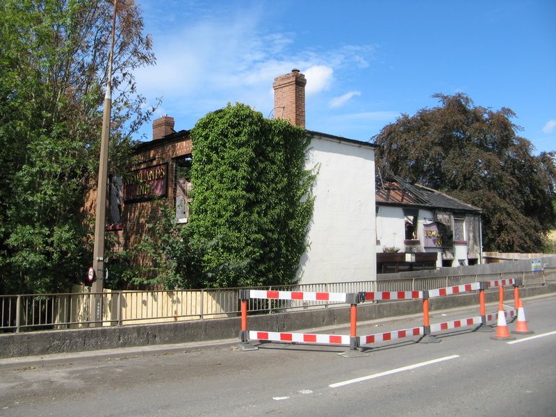
Former Newlands Inn
(Formerly listed as Newlands Inn)
II
Public house. Early C19 with C20 alterations and additions. Red brick, rendered to street elevation with brick and stucco dressings. Hipped plain tile and slate roofs with brick ridge stack to north range and brick side wall stack to south range. Two storeys, T-plan, three bay south range and four bay north range. South elevation has off-centre panelled door below margin glazed overlight, and glazing bar sashes to either side, two to east and one to west. Between western sash and door there are two C20 inserted openings. Three glazing bar sashes above. All openings below flat brick arches. Slate roof.
Street elevation has blank wall to south range and recessed to north a large C20 glazed porch covering two C20 doors, flanked by glazing bar sashes and with two C20 casements to north. Above four glazing bar sashes. All openings below stuccoed flat arches and with projecting sills. Stepped eaves to plain tile roof above.
Probably built to cater for traffic on the adjoining Cromford Canal.
Listing NGR: SK4229451243
External links are from the relevant listing authority and, where applicable, Wikidata. Wikidata IDs may be related buildings as well as this specific building. If you want to add or update a link, you will need to do so by editing the Wikidata entry.


Other nearby listed buildings