Approximate Location Map
Large Map »
Latitude: 54.251 / 54°15'3"N
Longitude: -2.8441 / 2°50'38"W
OS Eastings: 345096
OS Northings: 484254
OS Grid: SD450842
Mapcode National: GBR 8ML8.1W
Mapcode Global: WH837.8DWY
Plus Code: 9C6V7524+C8
Entry Name: Low Fell End Farmhouse
Listing Date: 3 April 1989
Grade: II
Source: Historic England
Source ID: 1335831
English Heritage Legacy ID: 77140
ID on this website: 101335831
Location: Mill Side, Westmorland and Furness, Cumbria, LA11
County: Cumbria
District: South Lakeland
Civil Parish: Witherslack, Meathop and Ulpha
Traditional County: Westmorland
Lieutenancy Area (Ceremonial County): Cumbria
Church of England Parish: Witherslack St Paul
Church of England Diocese: Carlisle
Tagged with: Farmhouse
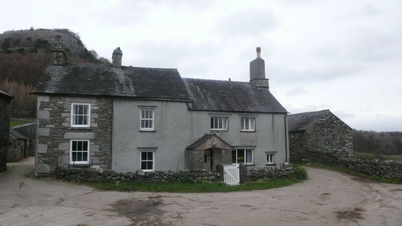
WITHERSLACK MILL SIDE
SD 48 SE
6/52 Low Fell End Farmhouse
II
Farmhouse. Probably C17 or early C18 with C19 addition. Roughcast stone with slate
roofs. South elevation of 2 storeys and 4 bays, the last 2 bays are higher, the C19
addition. 1st 2 bays have sashed windows with glazing bars; 2nd 2 bays have casements
and 4th bay has 2-light chamfered wooden-mullioned fire window. Entrance to 3rd bay
has wide-boarded studded doors, strap hinges with fleur-de-lys ends and wooden pull
handle; inset light. Gable-end stacks, that to east end is corbelled with rounded
shaft, and cross-axial stack. Rear has outshut under catslide roof with stack to east
return, and gabled wing with gable-end stack and end 1st floor entrance up steps.
Interior not inspected, said to contain winding stair and cambered fireplace beam.
Listing NGR: SD4509684254
External links are from the relevant listing authority and, where applicable, Wikidata. Wikidata IDs may be related buildings as well as this specific building. If you want to add or update a link, you will need to do so by editing the Wikidata entry.


Other nearby listed buildings
