Approximate Location Map
Large Map »
Latitude: 51.2816 / 51°16'53"N
Longitude: 0.7729 / 0°46'22"E
OS Eastings: 593476
OS Northings: 157260
OS Grid: TQ934572
Mapcode National: GBR RV0.Q6L
Mapcode Global: VHKK0.B1YV
Plus Code: 9F327QJF+J4
Entry Name: The Old Corner House
Listing Date: 21 March 1985
Grade: II
Source: Historic England
Source ID: 1335890
English Heritage Legacy ID: 176235
ID on this website: 101335890
Location: Doddington, Swale, Kent, ME9
County: Kent
District: Swale
Civil Parish: Doddington
Traditional County: Kent
Lieutenancy Area (Ceremonial County): Kent
Tagged with: House
TQ 95 NW DODDINGTON THE STREET
(north side)
4/25
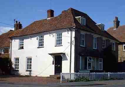
The Old Corner House
GV II
House. C18. Rendered with plain tiled roof. Two storeys with moulded
eaves cornice to hipped roof with central stack. Three glazing bar sashes
on first floor, 2 on ground floor, and a boarded door to right with flat
hood on brackets. Large projecting hipped oriel window on ground floor of
right return front. Included for group value only.
Listing NGR: TQ9347657260
External links are from the relevant listing authority and, where applicable, Wikidata. Wikidata IDs may be related buildings as well as this specific building. If you want to add or update a link, you will need to do so by editing the Wikidata entry.


Other nearby listed buildings
