Approximate Location Map
Large Map »
Latitude: 54.3839 / 54°23'1"N
Longitude: -2.5965 / 2°35'47"W
OS Eastings: 361354
OS Northings: 498871
OS Grid: SD613988
Mapcode National: GBR BK9R.N8
Mapcode Global: WH93X.22TL
Plus Code: 9C6V9CM3+G9
Entry Name: Milestone Approximately 40M from A685
Listing Date: 21 February 1989
Grade: II
Source: Historic England
Source ID: 1335923
English Heritage Legacy ID: 75663
ID on this website: 101335923
Location: Westmorland and Furness, Cumbria, LA8
County: Cumbria
District: South Lakeland
Civil Parish: Grayrigg
Traditional County: Westmorland
Lieutenancy Area (Ceremonial County): Cumbria
Church of England Parish: Grayrigg
Church of England Diocese: Carlisle
Tagged with: Milestone
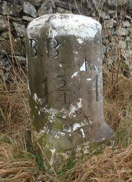
SD 69 NW GRAYRIGG B6257
(West side)
8/81 Milestone approx. 40m
from A685
II
Milestone. Early C19. Painted stone. Semicircular on plan, on square base
with broaches to angles. Inscribed: "BB : K/LONSDALE/1¼:14¼" (BB = Borrow
Bridge). Base has italic: "JM". Placed on Sedbergh to Grayrigg turnpike road,
1762.
Listing NGR: SD6135498871
External links are from the relevant listing authority and, where applicable, Wikidata. Wikidata IDs may be related buildings as well as this specific building. If you want to add or update a link, you will need to do so by editing the Wikidata entry.


Other nearby listed buildings
