Latitude: 51.4123 / 51°24'44"N
Longitude: 0.3164 / 0°18'58"E
OS Eastings: 561185
OS Northings: 170693
OS Grid: TQ611706
Mapcode National: GBR YX.SHH
Mapcode Global: VHHP2.FRMN
Plus Code: 9F32C868+WH
Entry Name: Former barn range with hop kilns approximately 40 metres to south of Hook Green Farmhouse
Listing Date: 17 March 1982
Grade: II
Source: Historic England
Source ID: 1336452
English Heritage Legacy ID: 172668
ID on this website: 101336452
Location: Hook Green, Dartford, Kent, DA13
County: Kent
District: Dartford
Civil Parish: Southfleet
Built-Up Area: Southfleet
Traditional County: Kent
Lieutenancy Area (Ceremonial County): Kent
Church of England Parish: Southfleet St Nicholas
Church of England Diocese: Rochester
Tagged with: Barn
This list entry was subject to a Minor Amendment on 4 September 2025 to amend the name and reformat the text to current standards
TQ 6170
12/34
SOUTHFLEET
HOOK GREEN ROAD (west side)
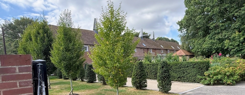
Former barn range with hopkilns approximately 40 metres to south of Hook Green Farmhouse
(Formerly listed as Barn range with hop-kilns approximately 40 m to south of Hook Green Farmhouse)
GV
II
C18 with C19 hopkilns. Two storeys, the front elevation of red brick, the rear elevation part roughcast. Hipped tiled roof. Seven unloading doors. The right hand portion has semi-circular windows on the ground floor and windows and loading doors above. Brick modillion cornice. Cross shaped iron ties. Four cowls and fantails.
Listing NGR: TQ6118170693
External links are from the relevant listing authority and, where applicable, Wikidata. Wikidata IDs may be related buildings as well as this specific building. If you want to add or update a link, you will need to do so by editing the Wikidata entry.


Other nearby listed buildings