Approximate Location Map
Large Map »
Latitude: 51.3357 / 51°20'8"N
Longitude: 1.4184 / 1°25'6"E
OS Eastings: 638207
OS Northings: 165170
OS Grid: TR382651
Mapcode National: GBR X0L.CF5
Mapcode Global: VHMCW.JPQF
Plus Code: 9F338CP9+79
Entry Name: Nos 5 to 17 and Railed Areas
Listing Date: 4 February 1988
Grade: II
Source: Historic England
Source ID: 1336643
English Heritage Legacy ID: 171726
ID on this website: 101336643
Location: Ramsgate, Thanet, Kent, CT11
County: Kent
District: Thanet
Civil Parish: Ramsgate
Built-Up Area: Ramsgate
Traditional County: Kent
Lieutenancy Area (Ceremonial County): Kent
Tagged with: Building
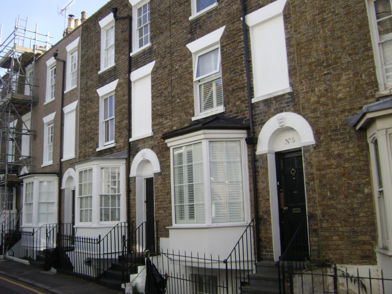
RAMSGATE CHURCH ROAD
TR 3865 SW
(east side)
9/97 Nos. 5 to 17
(odd numbers)
& railed areas
GV II
Terrace row. 1830's. Stock brick, No. 9 pebble dashed, with slate roofs.
Three storeys and basement, with parapet and stacks. Numbers 11 to 17
are stepped up from 5, 7 and 9. Two glazing bar sashes to each house
unit on 2nd floor (14 bays in all), and 1 to each on 1st floor with blank
window space to right. No. 9 with C20 replacement windows. Nos. 5, 7,
9 and 11 with canted bay windows with fluted pilasters, cornices and glazing
bar sashes (No. 9 with C20 replacements). Numbers 13, 15 and 17 with
glazing bar sash to left on ground floor (sash to No. 15). All openings
with rendered heads. Doors of 6 panels to right in semi-circular surrounds
with Coade stone key stones with bearded faces, and flights of 4 or 5
steps. Two sashes to basements. Simple rails to steps. Fleur-de-lys
rails to basement areas.
Listing NGR: TR3820965169
External links are from the relevant listing authority and, where applicable, Wikidata. Wikidata IDs may be related buildings as well as this specific building. If you want to add or update a link, you will need to do so by editing the Wikidata entry.


Other nearby listed buildings
