Approximate Location Map
Large Map »
Latitude: 51.2781 / 51°16'41"N
Longitude: 1.0854 / 1°5'7"E
OS Eastings: 615282
OS Northings: 157740
OS Grid: TR152577
Mapcode National: GBR TY2.Z2R
Mapcode Global: VHLGM.R4NJ
Plus Code: 9F3373HP+64
Entry Name: The Duke's Head Inn
Listing Date: 3 May 1967
Grade: II
Source: Historic England
Source ID: 1336813
English Heritage Legacy ID: 170576
ID on this website: 101336813
Location: Canterbury, Kent, CT1
County: Kent
District: Canterbury
Electoral Ward/Division: Barton
Parish: Non Civil Parish
Built-Up Area: Canterbury
Traditional County: Kent
Lieutenancy Area (Ceremonial County): Kent
Tagged with: Inn
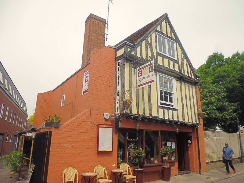
1.
944 CHURCH STREET
ST PAUL'S
(North Side)
No 4 (The Duke's Head Inn)
TR 1557 NW 5/153 3.5.67.
II
2.
A C16 timber framed building restored and with some timbers renewed. 3
storeys. Overhanging gable with 2nd floor window in it. 3 sashes with-some
glazing bars intact. The lst floor projects on the protruding ends of the floor
joists. Modern pub front.
Listing NGR: TR1528257740
External links are from the relevant listing authority and, where applicable, Wikidata. Wikidata IDs may be related buildings as well as this specific building. If you want to add or update a link, you will need to do so by editing the Wikidata entry.


Other nearby listed buildings
