Latitude: 54.5807 / 54°34'50"N
Longitude: -1.7991 / 1°47'56"W
OS Eastings: 413080
OS Northings: 520626
OS Grid: NZ130206
Mapcode National: GBR HHWG.9Q
Mapcode Global: WHC5L.B4H6
Plus Code: 9C6WH6J2+78
Entry Name: Group of 4 Headstones Approximately 5 Metres West of Church of St. Mary
Listing Date: 30 September 1987
Grade: II
Source: Historic England
Source ID: 1338614
English Heritage Legacy ID: 111496
ID on this website: 101338614
Location: St Mary's Church, Staindrop, County Durham, DL2
County: County Durham
Civil Parish: Staindrop
Built-Up Area: Staindrop
Traditional County: Durham
Lieutenancy Area (Ceremonial County): County Durham
Church of England Parish: Staindrop
Church of England Diocese: Durham
Tagged with: Tombstone
STAINDROP FRONT STREET
NZ 1320
(North side)
18/131 Group of 4
headstones
approximately 5
metres west of
Church of St. Mary
GV II
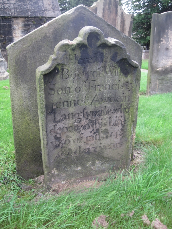
4 headstones. Circa 1702 for Ralph ? Lawson, 1748 for William Awde, 1768 for
Ralph Sidgwick and 1778 for William Wheatley. Sandstone ashlar. Sidgwick and
Wheatley facing east, the others facing west and backing onto them.
1. Sidgwick at south-east of group: slab c.O.9 metre high, moulded with
pediment and deeply-cut inscription.
2. Wheatley at north-east: slab c.1 metre high with bracketed scrolled top,
the scrolls linked by swags on tooled background, and well-cut inscription.
Verse on rear.
3. Awde at south-west: shaped-top slab c.0.7 metre high with moulded surround.
4. ? Lawson. Scroll-topped slab c.0.5 metre high with ogee-patterned edge
moulding; low-relief face between top spirals, with 17 and 02 either side.
Large-lettered inscription, partly obscured by vegetation, continues up
sides and on rear.
All 4 include other members of the families.
Listing NGR: NZ1308020626
External links are from the relevant listing authority and, where applicable, Wikidata. Wikidata IDs may be related buildings as well as this specific building. If you want to add or update a link, you will need to do so by editing the Wikidata entry.


Other nearby listed buildings