Approximate Location Map
Large Map »
Latitude: 54.5916 / 54°35'29"N
Longitude: -1.802 / 1°48'7"W
OS Eastings: 412890
OS Northings: 521842
OS Grid: NZ128218
Mapcode National: GBR HHVB.NT
Mapcode Global: WHC5D.9V4C
Plus Code: 9C6WH5RX+J5
Entry Name: North Gatehouse and Walls Attached Enclosing Castle; Gate House Formerly Listed As 'Porter's Lodge'
Listing Date: 14 September 1966
Last Amended: 30 September 1987
Grade: I
Source: Historic England
Source ID: 1338626
English Heritage Legacy ID: 111448
ID on this website: 101338626
Location: Raby, County Durham, DL2
County: County Durham
Civil Parish: Raby with Keverstone
Traditional County: Durham
Lieutenancy Area (Ceremonial County): County Durham
Church of England Parish: Staindrop
Church of England Diocese: Durham
Tagged with: Gatehouse
RABY WITH KEVERSTONE RABY PARK
NZ 1221
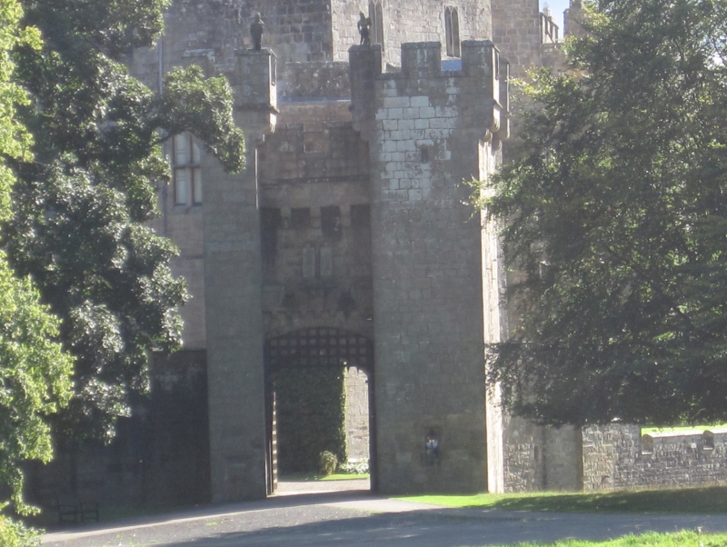
16/83 North gatehouse
14/9/66 and walls attached
enclosing castle;
gatehouse formerly
listed as
'Porter's Lodge'
GV I
Castle gatehouse and castle wall. C14, with C18 alterations by J. Carr.
Coursed sandstone blocks with ashlar dressings; wall of similar materials.
2-storey gatehouse. Wide segmental portcullis arch under corbelled balcony;
2-light window above with cusped ogee heads; machicolations below top parapet
with crenellations. Flanking turrets,narrower at left, crenellated, with
square-headed chamfered surrounds to door at left, and to 3-foil-headed window
at right. Machicolated returns to turrets. Life-size figures on battlements
resited from east barbican, now demolished, and from guard tower. Flanking
walls stepped down, with blind quatrefoil decoration, to lower turrets. From
these the encircling wall, reduced to c. one metre above level of castle yard,
tops retaining wall along inner edge of moat, with square projections, flat
buttresses, battered lower courses on south,and segmental-arched entrance
from moat on south-east.
Listing NGR: NZ1288521834
External links are from the relevant listing authority and, where applicable, Wikidata. Wikidata IDs may be related buildings as well as this specific building. If you want to add or update a link, you will need to do so by editing the Wikidata entry.


Other nearby listed buildings
