Approximate Location Map
Large Map »
Latitude: 51.2271 / 51°13'37"N
Longitude: -1.3427 / 1°20'33"W
OS Eastings: 445994
OS Northings: 147748
OS Grid: SU459477
Mapcode National: GBR 842.3BZ
Mapcode Global: VHD09.PF15
Plus Code: 9C3W6MG4+RW
Entry Name: Church of All Hallows
Listing Date: 16 May 1966
Grade: II*
Source: Historic England
Source ID: 1339652
English Heritage Legacy ID: 139378
ID on this website: 101339652
Location: All Hallows' Church, Whitchurch, Basingstoke and Deane, Hampshire, RG28
County: Hampshire
District: Basingstoke and Deane
Civil Parish: Whitchurch
Built-Up Area: Whitchurch
Traditional County: Hampshire
Lieutenancy Area (Ceremonial County): Hampshire
Church of England Parish: Whitchurch with Tufton with Litchfield
Church of England Diocese: Winchester
Tagged with: Church building
1.
5229 WHITCHURCH CHURCH STREET
SU 45/4647 16.5.66 Church of All Hallows
SU 45/4648
5/40
II*
2.
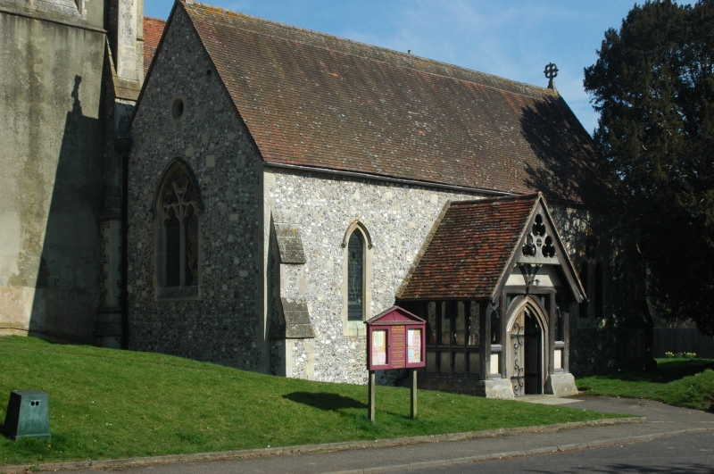
Norman, Perpendicular, but mainly a restoration of 1866 by Benjamin Ferrey. Nave of
4 bays with wide north and south aisles, chancel, west tower, and south porch. The
nave arcades have pointed arches, with cylindrical (Norman) columns on the south side
on square bases, and shafted (Perp) columns on the north side, on the old square bases
(the 2 western being original); old pointed tower arch; the base of the tower is C15,
with a timber newel stair, with C17 alterations and restoration upper parts. Within,
there is a C15 octagonal font, brasses (of Sir Richard Brooke died 1593 and wife
Elizabeth) and 2 limestone effigies (of Thomas Brooke died 1612 and wife Susanna) on a
modern altar tomb. Frishburga's stone is a C10 arch-headed fragment with a bust
within a recess. The exterior is entirely Victorian, Early English, with lancets,
plate tracery, circular high lights, and Geometrical windows in the gables of aisles
and chancel. Walls are of flint and stone rubble, with stone dressings including
shallow buttresses having steep weatherings; the tower is rendered. Steep tile
roofing and shingled broach spire to the Tower. Half-glazed timber-framed porch on a
stone plinth.
Listing NGR: SU4616847946
External links are from the relevant listing authority and, where applicable, Wikidata. Wikidata IDs may be related buildings as well as this specific building. If you want to add or update a link, you will need to do so by editing the Wikidata entry.


Other nearby listed buildings
