Approximate Location Map
Large Map »
Latitude: 51.3405 / 51°20'25"N
Longitude: -1.2126 / 1°12'45"W
OS Eastings: 454945
OS Northings: 160451
OS Grid: SU549604
Mapcode National: GBR 941.S9Q
Mapcode Global: VHCZS.XKTQ
Plus Code: 9C3W8QRP+6X
Entry Name: Granary 40 Yards South West of Pit House
Listing Date: 18 May 1984
Grade: II
Source: Historic England
Source ID: 1339758
English Heritage Legacy ID: 138225
ID on this website: 101339758
Location: Fair Oak, Basingstoke and Deane, Hampshire, RG19
County: Hampshire
District: Basingstoke and Deane
Civil Parish: Ashford Hill with Headley
Traditional County: Hampshire
Lieutenancy Area (Ceremonial County): Hampshire
Church of England Parish: Ashford Hill with Headley
Church of England Diocese: Winchester
Tagged with: Granary
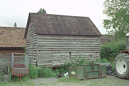
SU 56 SW KINGSCLERE PITHOUSE LANE
3/40
Granary 40 yds
south-west of
Pit House
II
Early C19. Timber-frame on 9 staddles. Corrugated iron roof. Boarded walls.
Listing NGR: SU5283757840
External links are from the relevant listing authority and, where applicable, Wikidata. Wikidata IDs may be related buildings as well as this specific building. If you want to add or update a link, you will need to do so by editing the Wikidata entry.


Other nearby listed buildings
