Approximate Location Map
Large Map »
Latitude: 51.3199 / 51°19'11"N
Longitude: -1.2524 / 1°15'8"W
OS Eastings: 452192
OS Northings: 158131
OS Grid: SU521581
Mapcode National: GBR 94C.26J
Mapcode Global: VHCZZ.72RZ
Plus Code: 9C3W8P9X+X2
Entry Name: Stable 40 Yards North East of Gaily House
Listing Date: 18 May 1984
Grade: II
Source: Historic England
Source ID: 1339769
English Heritage Legacy ID: 138281
ID on this website: 101339769
Location: Kingsclere, Basingstoke and Deane, Hampshire, RG20
County: Hampshire
District: Basingstoke and Deane
Town: Basingstoke and Deane
Civil Parish: Kingsclere
Built-Up Area: Kingsclere
Traditional County: Hampshire
Lieutenancy Area (Ceremonial County): Hampshire
Church of England Parish: Kingsclere
Church of England Diocese: Winchester
Tagged with: Stable
SU 55 NW KINGSCLERE
8/30
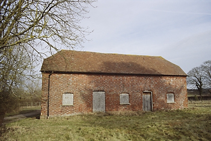
Stable 40 yds north-east
of Gaily House
GV
II
Early C19. Rectangular block of 2 storeys. Half-hipped tile roof, brick dentil
eaves. Red brick walling in Flemish bond with blue headers, cambered openings,
plinth. Included for group value.
Listing NGR: SU5283757840
External links are from the relevant listing authority and, where applicable, Wikidata. Wikidata IDs may be related buildings as well as this specific building. If you want to add or update a link, you will need to do so by editing the Wikidata entry.


Other nearby listed buildings
