Approximate Location Map
Large Map »
Latitude: 51.6356 / 51°38'8"N
Longitude: -2.1595 / 2°9'34"W
OS Eastings: 389054
OS Northings: 192994
OS Grid: ST890929
Mapcode National: GBR 1P0.DT9
Mapcode Global: VH95K.J46Y
Plus Code: 9C3VJRPR+75
Entry Name: Unidentifed Memorial, About 1 Metre North West of North East Path at 11 Metres from Crossing in Churchyard of Church of St Mary
Listing Date: 21 March 1985
Grade: II*
Source: Historic England
Source ID: 1341195
English Heritage Legacy ID: 128454
ID on this website: 101341195
Location: St Mary's Church, Tetbury, Cotswold, Gloucestershire, GL8
County: Gloucestershire
District: Cotswold
Civil Parish: Tetbury
Built-Up Area: Tetbury
Traditional County: Gloucestershire
Lieutenancy Area (Ceremonial County): Gloucestershire
Church of England Parish: Tetbury St Mary the Virgin
Church of England Diocese: Gloucester
Tagged with: Architectural structure
ST 8892-8992 TETBURY CHURCH STREET
(Inset, section D) (east side)
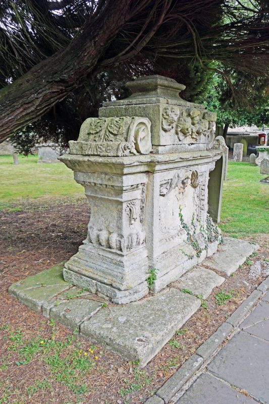
8/178 Unidentified memorial, about lm
north west of north east path at
llm from path crossing in churchyard
of Church of St. Mary
II*
Large chest tomb. Mid C18. Limestone. Rectangular with indented
corners. Tall moulded plinth on large base, moulded capping, heavy
baluster ends with upturned gadroon decoration along base, egg and
dart frieze at top and small drapery swathes on returns to south
east. Central rectangular panel with egg and dart moulding to
south with oval inscription panel surmounted by cherub and drapery
swathes. Tall oval panel with festooned drapery to north. Large cap
with elaborately scrolled ends and square centre with high relief
of 5 cherub heads to south, 3 skulls to north, and moulded
rectangular finial. An unusually rich work in a very rich
churchyard.
Listing NGR: ST8905492994
External links are from the relevant listing authority and, where applicable, Wikidata. Wikidata IDs may be related buildings as well as this specific building. If you want to add or update a link, you will need to do so by editing the Wikidata entry.


Other nearby listed buildings
