Approximate Location Map
Large Map »
Latitude: 51.639 / 51°38'20"N
Longitude: -2.1554 / 2°9'19"W
OS Eastings: 389339
OS Northings: 193365
OS Grid: ST893933
Mapcode National: GBR 1P0.7VB
Mapcode Global: VH95K.L2CC
Plus Code: 9C3VJRQV+HR
Entry Name: The Royal Oak
Listing Date: 21 March 1985
Grade: II
Source: Historic England
Source ID: 1341199
English Heritage Legacy ID: 128483
ID on this website: 101341199
Location: Tetbury, Cotswold, Gloucestershire, GL8
County: Gloucestershire
District: Cotswold
Civil Parish: Tetbury
Built-Up Area: Tetbury
Traditional County: Gloucestershire
Lieutenancy Area (Ceremonial County): Gloucestershire
Church of England Parish: Tetbury St Mary the Virgin
Church of England Diocese: Gloucester
Tagged with: Architectural structure
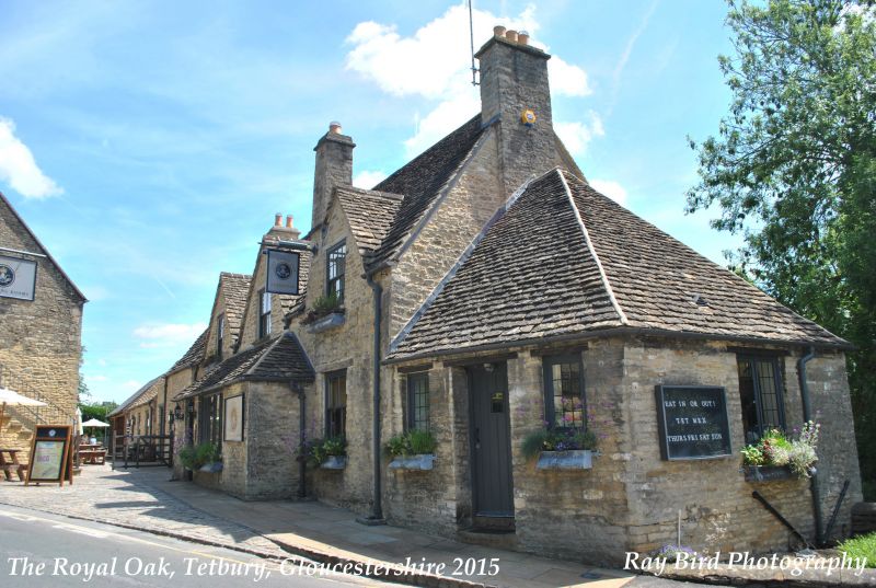
ST 8893-8993 TETBURY CIRENCESTER ROAD
(south side)
7/209 The Royal Oak
II
Inn. Late C17/early C18, with additions of early C20. Rubble
stone, Cotswold stone slate roof, stone stacks. Single range with
3 gables to Cirencester Road, single storey basement and attic, and
3 small gabled dormers to rear lane with basement coming out at
street level. Inserted central porch across middle gable and to
each side, replacing central gabled porch. Hipped polygonal wing
added to west end. 3 windows, C19 sashes. Recorded as an inn
since 1781.
(Victoria Country History, Gloucestershire Vol Xl, 1976).
Listing NGR: ST8933993365
External links are from the relevant listing authority and, where applicable, Wikidata. Wikidata IDs may be related buildings as well as this specific building. If you want to add or update a link, you will need to do so by editing the Wikidata entry.


Other nearby listed buildings
