Approximate Location Map
Large Map »
Latitude: 51.6362 / 51°38'10"N
Longitude: -2.1595 / 2°9'34"W
OS Eastings: 389054
OS Northings: 193054
OS Grid: ST890930
Mapcode National: GBR 1P0.6V6
Mapcode Global: VH95K.J46J
Plus Code: 9C3VJRPR+F5
Entry Name: The Vicarage
Listing Date: 6 September 1954
Grade: II
Source: Historic England
Source ID: 1341202
English Heritage Legacy ID: 128497
ID on this website: 101341202
Location: Tetbury, Cotswold, Gloucestershire, GL8
County: Gloucestershire
District: Cotswold
Civil Parish: Tetbury
Built-Up Area: Tetbury
Traditional County: Gloucestershire
Lieutenancy Area (Ceremonial County): Gloucestershire
Church of England Parish: Tetbury St Mary the Virgin
Church of England Diocese: Gloucester
Tagged with: Clergy house
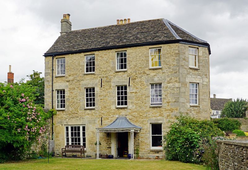
ST 8893-8993 TETBURY THE GREEN
(north side)
7/223 The Vicarage
6.9.54
GV II
Large detached vicarage. Front range dated 1771, with earlier
ranges behind of early C18 and probably late Cl6. Rubble stone,
random coursed on front range with some punched stone and some
snecking. Cotswold stone slate roof with stone stacks. Long L-
shape range with polygonal right return to front range. 3
storeys. 4 windows across straight wall, 12-pane sashes with large
stone lintels, 9-pane on top storey. Two C19 sashes on ground
floor, plate glass to right, triple glazing bar sash to left, with
early C19 central iron porch supported in front only with swept
lead roof. Doorway has side pilasters and original door which now
has large glazed panel at top and single horizontal moulded panel
below. Polygon windows as main facade with oval plaque "1771 JW"
on blind centre wall. At rear, very large stepped stone external
stack with blocked opening, probably of late C16, with small 2-
storey wing with parapet joined to L-shape wing of early C18 of 3
storeys, with 12-pane sashes, and C19 sashes to ground floor,
across front of which is range of 1771.
Listing NGR: ST8905493054
External links are from the relevant listing authority and, where applicable, Wikidata. Wikidata IDs may be related buildings as well as this specific building. If you want to add or update a link, you will need to do so by editing the Wikidata entry.


Other nearby listed buildings
