Latitude: 51.6938 / 51°41'37"N
Longitude: -1.6903 / 1°41'25"W
OS Eastings: 421503
OS Northings: 199495
OS Grid: SU215994
Mapcode National: GBR 4ST.RH8
Mapcode Global: VHC0B.NP8D
Plus Code: 9C3WM8V5+GV
Entry Name: Unidentified Monument, Immediately South of South Chapel in Churchyard of Church of St Lawrence
Listing Date: 4 July 1985
Grade: II
Source: Historic England
Source ID: 1341323
English Heritage Legacy ID: 129032
ID on this website: 101341323
Location: St Lawrence's Church, Lechlade-on-Thames, Cotswold, Gloucestershire, GL7
County: Gloucestershire
District: Cotswold
Civil Parish: Lechlade
Built-Up Area: Lechlade-on-Thames
Traditional County: Gloucestershire
Lieutenancy Area (Ceremonial County): Gloucestershire
Church of England Parish: Lechlade St Lawrence
Church of England Diocese: Gloucester
Tagged with: Monument
SU 2199 LECHLADE MARKET PLACE (east side)
10/187 Unidentified Monument, immediately south of south chapel in churchyard of Church of St. Lawrence
GV II
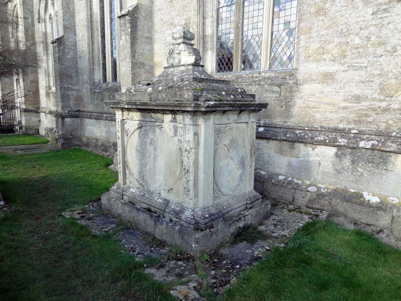
Large chest tomb. Mid/late C18. Limestone. Moulded plinth and capping on plain base set on larger base formerly railed. Fluted frieze with projecting pilasters at all corners. Ends have vertical oval panels with carved foliage surround and flanking fluted pilasters. South side has horizontal oval with elaborately carved cherub and foliage spandrels and flanking high relief pilasters. North side has incised horizontal oval and plain flanking pilasters. Both pilasters missing at north west corner. Large 3-step pyramidal cap rising to carved finial partially missing. The whole considerably eroded and cracking and all inscriptions obliterated.
Listing NGR: SU2150399495
External links are from the relevant listing authority and, where applicable, Wikidata. Wikidata IDs may be related buildings as well as this specific building. If you want to add or update a link, you will need to do so by editing the Wikidata entry.


Other nearby listed buildings