Latitude: 51.7532 / 51°45'11"N
Longitude: -2.0225 / 2°1'20"W
OS Eastings: 398543
OS Northings: 206056
OS Grid: SO985060
Mapcode National: GBR 2P4.5GG
Mapcode Global: VHB2H.W6NB
Plus Code: 9C3VQX3H+72
Entry Name: Unidentified Monument in the Churchyard Approximately 4M South of Chancel to Church of St Michael
Listing Date: 24 June 1985
Grade: II
Source: Historic England
Source ID: 1341816
English Heritage Legacy ID: 127187
ID on this website: 101341816
Location: St Michael's Church, Duntisbourne Rouse, Cotswold, Gloucestershire, GL7
County: Gloucestershire
District: Cotswold
Civil Parish: Duntisbourne Rouse
Traditional County: Gloucestershire
Lieutenancy Area (Ceremonial County): Gloucestershire
Church of England Parish: Duntisbourne Abbots St Peter
Church of England Diocese: Gloucester
Tagged with: Monument
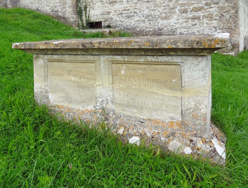
DUNTISBOURNE ROUSE DUNTISBOURNE ROUSE VILLAGE SO 90 NE 6/87 Unidentified monument in the churchyard approximately 4m south of chancel to Church of St. Michael GV II
Chest tomb. C18. Limestone. Sides have 2 recessed inscription panels with beaded mouldings; plain ends. Chamfered base and cavetto moulded top. Inscriptions added in late C19 and early C20. Inscribed on south side to MARY LOUISA, died 1873; and ELIZA BOULTON, died 1901; on north side to WILLIAM BOULTON, died 1892; and SARAH, died 1887.
Listing NGR: SO9854306056
External links are from the relevant listing authority and, where applicable, Wikidata. Wikidata IDs may be related buildings as well as this specific building. If you want to add or update a link, you will need to do so by editing the Wikidata entry.


Other nearby listed buildings