Approximate Location Map
Large Map »
Latitude: 52.4233 / 52°25'23"N
Longitude: -1.5595 / 1°33'34"W
OS Eastings: 430052
OS Northings: 280678
OS Grid: SP300806
Mapcode National: GBR H2G.BB
Mapcode Global: VHBWX.XCF5
Plus Code: 9C4WCCFR+86
Entry Name: 62 and 64, Birmingham Road
Listing Date: 5 February 1955
Grade: II
Source: Historic England
Source ID: 1342902
English Heritage Legacy ID: 218438
ID on this website: 101342902
Location: Coventry, West Midlands, CV5
County: Coventry
Electoral Ward/Division: Bablake
Parish: Non Civil Parish
Built-Up Area: Coventry
Traditional County: Warwickshire
Lieutenancy Area (Ceremonial County): West Midlands
Church of England Parish: Allesley All Saints
Church of England Diocese: Coventry
Tagged with: Building
1.
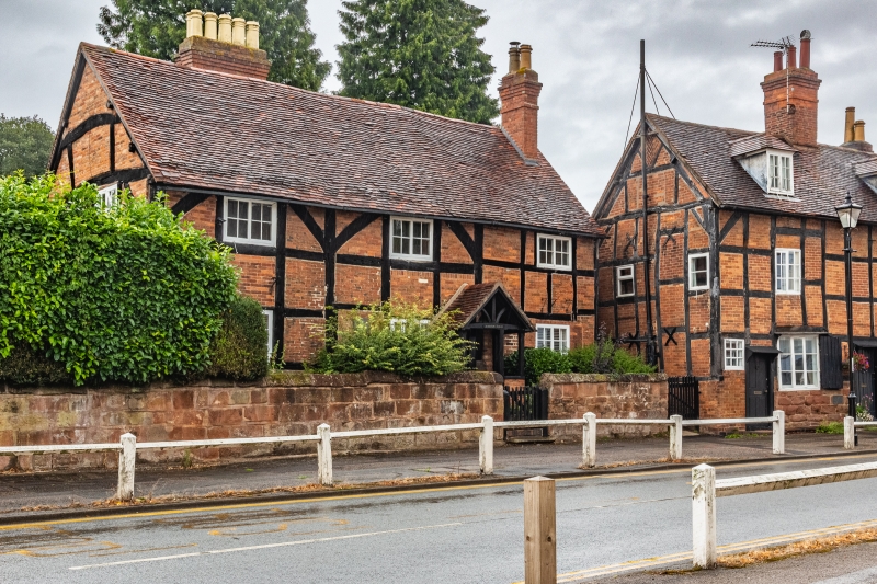
5105 BIRMINGHAM ROAD
(North Side)
ALLESLEY
---------------
Nos 62 & 64
SP 3080 NW 5/123 5.2.55.
II GV
2.
Late C16. Stone plinth, timber frame, old brick flogging, old tiled roof. 2 storeys,
3 flush C19 casement windows with glazing bars. C19 gabled wood porch with tiled
roof.
The Lodge and Nos 42 to 64 (even) form a group.
Listing NGR: SP3005780678
External links are from the relevant listing authority and, where applicable, Wikidata. Wikidata IDs may be related buildings as well as this specific building. If you want to add or update a link, you will need to do so by editing the Wikidata entry.


Other nearby listed buildings
