Approximate Location Map
Large Map »
Latitude: 52.3891 / 52°23'20"N
Longitude: -1.6211 / 1°37'16"W
OS Eastings: 425880
OS Northings: 276852
OS Grid: SP258768
Mapcode National: GBR 5KX.BXJ
Mapcode Global: VHBX2.V6BV
Plus Code: 9C4W99QH+JG
Entry Name: Crabmill Farmhouse
Listing Date: 22 July 1976
Grade: II
Source: Historic England
Source ID: 1343223
English Heritage Legacy ID: 218133
ID on this website: 101343223
Location: Beechwood, Solihull, West Midlands, CV7
County: Solihull
Civil Parish: Berkswell
Traditional County: Warwickshire
Lieutenancy Area (Ceremonial County): West Midlands
Church of England Parish: Berkswell St John the Baptist
Church of England Diocese: Coventry
Tagged with: Farmhouse
BERKSWELL WASTE LANE
1.
5108
(North Side)
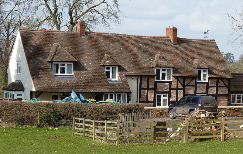
Crabmill Farmhouse
SP 27 NE 12/266
II
2.
Late C16 or early C17. Timber frame, whitewashed brick, tiled roof with 4 hipped
dormers. 1 storey and attics, modern flush lattice casement windows. Back wing.
Listing NGR: SP2588076852
External links are from the relevant listing authority and, where applicable, Wikidata. Wikidata IDs may be related buildings as well as this specific building. If you want to add or update a link, you will need to do so by editing the Wikidata entry.


Other nearby listed buildings
