Latitude: 51.2745 / 51°16'28"N
Longitude: 1.3428 / 1°20'34"E
OS Eastings: 633252
OS Northings: 158130
OS Grid: TR332581
Mapcode National: GBR X18.48Y
Mapcode Global: VHLGS.7788
Plus Code: 9F3378FV+R4
Entry Name: Ferryway
Listing Date: 19 May 1950
Grade: II
Source: Historic England
Source ID: 1343747
English Heritage Legacy ID: 177395
ID on this website: 101343747
Location: Sandwich, Dover, Kent, CT13
County: Kent
District: Dover
Civil Parish: Sandwich
Built-Up Area: Sandwich
Traditional County: Kent
Lieutenancy Area (Ceremonial County): Kent
Tagged with: Building
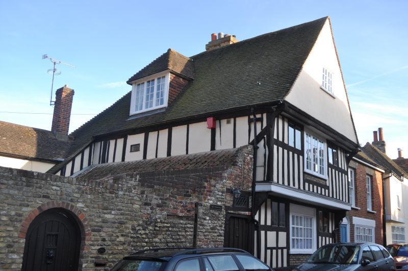
1.
5275 FISHER STREET
(East Side)
No 1 (Ferryway)
TR 3358 1/162 19.5.50.
II GV
2.
C15 timber framed house on a rubble base. Ground and 1st floor studded. lst
floor overhangs on carved brackets and bressummer. Similarly overhanging gable
plastered. C18 horizontally sliding sash windows with glazing bars intact
on ground floor. Modern casement window above. Several blocked original windows.
Nos 1 to 33 (odd) with Nos 7 to 15 (odd) Church Street St Clement form a group.
Listing NGR: TR3325558126
External links are from the relevant listing authority and, where applicable, Wikidata. Wikidata IDs may be related buildings as well as this specific building. If you want to add or update a link, you will need to do so by editing the Wikidata entry.


Other nearby listed buildings