Approximate Location Map
Large Map »
Latitude: 51.1351 / 51°8'6"N
Longitude: 1.2994 / 1°17'57"E
OS Eastings: 630918
OS Northings: 142489
OS Grid: TR309424
Mapcode National: GBR W1F.RBX
Mapcode Global: VHLHB.GQSQ
Plus Code: 9F3347PX+2P
Entry Name: Former Buckland Flour Mill (Adjoining Number 110 to the Left)
Listing Date: 17 December 1973
Grade: II
Source: Historic England
Source ID: 1343826
English Heritage Legacy ID: 177783
ID on this website: 101343826
Location: Buckland, Dover, Kent, CT16
County: Kent
District: Dover
Civil Parish: Dover
Built-Up Area: Dover
Traditional County: Kent
Lieutenancy Area (Ceremonial County): Kent
Tagged with: Mill building
LONDON ROAD
1. (North East Side)
1050
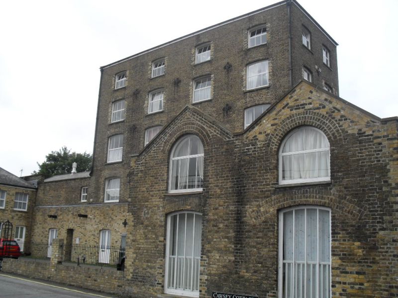
Former Buckland Flour Mill
(adjoining No 110 to the
left)
TR 3042 4/120
II GV
2.
Circa 1840. It consists of a 4 storeyed weatherboarded section to the left.
This has round-headed sashes and a lucam. 5 sashes to the side elevation.
There is a 5 storey brown brick section to the right with 6 cambered sashes,
pilasters and dentil band. 2 storey brown brick protruding section to the
right.
The listed buildings from No lo7 to No 116 form a group.
Listing NGR: TR3091842489
External links are from the relevant listing authority and, where applicable, Wikidata. Wikidata IDs may be related buildings as well as this specific building. If you want to add or update a link, you will need to do so by editing the Wikidata entry.


Other nearby listed buildings
