Approximate Location Map
Large Map »
Latitude: 51.3153 / 51°18'54"N
Longitude: 0.8922 / 0°53'31"E
OS Eastings: 601650
OS Northings: 161322
OS Grid: TR016613
Mapcode National: GBR SW3.JDK
Mapcode Global: VHKJW.F61K
Plus Code: 9F328V8R+4V
Entry Name: 4, East Street
Listing Date: 3 August 1972
Grade: II
Source: Historic England
Source ID: 1343839
English Heritage Legacy ID: 175915
ID on this website: 101343839
Location: Faversham, Swale, Kent, ME13
County: Kent
District: Swale
Civil Parish: Faversham
Built-Up Area: Faversham
Traditional County: Kent
Lieutenancy Area (Ceremonial County): Kent
Tagged with: Building
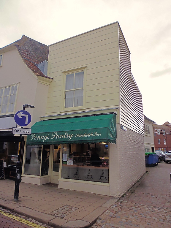
EAST STREET
1. -----------
1103
No 4
TR 0161 SE 3/40
II GV
2.
House presently listed as No 4 comprises late C18 extension to No 3A.
2 storeys. I window [with glazing bars]. 1st floor faced with
horizontal boarding cut to resemble masonry. Ground floor includes
part of older building. Late C19 shop front. East side weather-
boarded.
Nos 2 to 5 (consec) form a group.
Listing NGR: TR0164961322
External links are from the relevant listing authority and, where applicable, Wikidata. Wikidata IDs may be related buildings as well as this specific building. If you want to add or update a link, you will need to do so by editing the Wikidata entry.


Other nearby listed buildings
