Latitude: 51.014 / 51°0'50"N
Longitude: -3.1032 / 3°6'11"W
OS Eastings: 322707
OS Northings: 124427
OS Grid: ST227244
Mapcode National: GBR M1.JFMW
Mapcode Global: FRA 46DF.LVG
Plus Code: 9C3R2V7W+JP
Entry Name: 2-4, High Street
Listing Date: 17 December 1973
Grade: II
Source: Historic England
Source ID: 1344755
English Heritage Legacy ID: 269761
ID on this website: 101344755
Location: Taunton, Somerset, TA1
County: Somerset
District: Somerset West and Taunton
Electoral Ward/Division: Taunton Manor and Wilton
Parish: Non Civil Parish
Built-Up Area: Taunton
Traditional County: Somerset
Lieutenancy Area (Ceremonial County): Somerset
Tagged with: Building
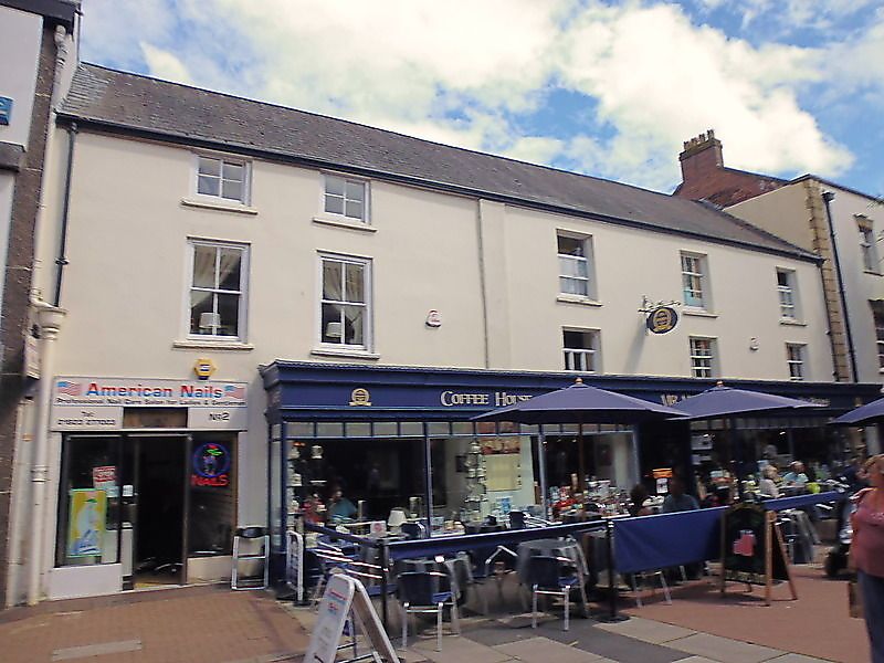
1. HIGH STREET
5365.
(East Side)
Nos 2 to 4 (consec)
ST 2224 SE 11/91 17.12.73
II GV
2.
Probably C18 or earlier structure. Low 3 storey stucco front with pilaster in
centre. Continuous slate roof. 5 windows, mostly sashes with glazing bars, late
Cl9 shop fronts, double doors to left. Included for group value.
Nos 2 to 14 (consec) form a group.
Listing NGR: ST2270724427
External links are from the relevant listing authority and, where applicable, Wikidata. Wikidata IDs may be related buildings as well as this specific building. If you want to add or update a link, you will need to do so by editing the Wikidata entry.


Other nearby listed buildings