Approximate Location Map
Large Map »
Latitude: 51.1762 / 51°10'34"N
Longitude: -3.3399 / 3°20'23"W
OS Eastings: 306433
OS Northings: 142734
OS Grid: ST064427
Mapcode National: GBR LQ.61PT
Mapcode Global: VH6GP.2P6Q
Plus Code: 9C3R5MG6+F3
Entry Name: St Decuman's Well, North West of Parish Church
Listing Date: 29 December 1982
Grade: II
Source: Historic England
Source ID: 1345561
English Heritage Legacy ID: 264606
ID on this website: 101345561
Location: St Decumans, Somerset, TA23
County: Somerset
District: Somerset West and Taunton
Civil Parish: Watchet
Built-Up Area: Watchet
Traditional County: Somerset
Lieutenancy Area (Ceremonial County): Somerset
Tagged with: Architectural structure
BRENDON ROAD
1.
5366
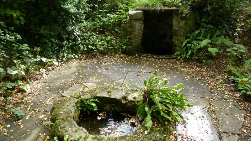
St Decuman's Well,
north-west of parish
church
ST 0642 3/4
II
2.
C19 reconstruction of probably late mediaeval Well with legendary associations with
St Decuman.
Circular well-head with random rubble stone walls, covered by a single flat stone
and grass. Water discharges into 2 round fronted 'D' shaped stone troughs set in
stone paving slabs. Well approached by a steep flight of stone steps (not included).
Listing NGR: ST0643242732
External links are from the relevant listing authority and, where applicable, Wikidata. Wikidata IDs may be related buildings as well as this specific building. If you want to add or update a link, you will need to do so by editing the Wikidata entry.


Other nearby listed buildings
