Approximate Location Map
Large Map »
Latitude: 50.9437 / 50°56'37"N
Longitude: -2.6636 / 2°39'48"W
OS Eastings: 353475
OS Northings: 116235
OS Grid: ST534162
Mapcode National: GBR MM.NYV7
Mapcode Global: FRA 569M.440
Plus Code: 9C2VW8VP+FH
Entry Name: Church of St James with Its South Boundary Wall
Listing Date: 19 March 1951
Grade: II*
Source: Historic England
Source ID: 1346135
English Heritage Legacy ID: 261404
Also known as: Church of St James, Preston Plucknett
ID on this website: 101346135
Location: St James' Church, Preston Plucknett, Somerset, BA20
County: Somerset
District: South Somerset
Civil Parish: Yeovil
Built-Up Area: Yeovil
Traditional County: Somerset
Lieutenancy Area (Ceremonial County): Somerset
Tagged with: Church building
ST51NW YEOVIL CP PRESTON ROAD (North side)
PRESTON PLUCKNETT
1/66 Church of St James with its South
boundary wall
19.3.51
- II*
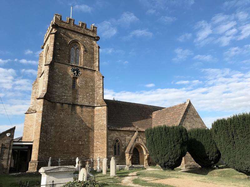
Built in 1420 as a chapelry, substantially rebuilt in the C19, architect
unknown. Ham stone, with some local cut and squared stone: plain clay tiled
roofs with alternating double courses of fish scale tiles, and with 2-courses
stone slates at eaves. Cruciform plan with West Tower, and 1950's vestry in NE
corner. Tower may be original in part; diagonal buttresses with offsets and
string courses defining each level; small cinquefoil window to hellringers
chamber, with C19 clockface over and C15 style traceried windows to bell
chamber; battlemented copings, gargoyle spouts to each corner. Most of remaining
work of C19 in early C15 style, but North transept day be earlier, the North
window (on which others are based, uniquely has no hood mould). Interior almost
totally of C19 and unremarkable: some pre-C19 memorials in North transept and
the tower space. In a case on the North nave wall the head of the medieval
churchyard cross (see below). The South boundary wall to the churchyard, stone,
approximately 1.5 metres high and some 42 metres long, with roll moulded coping,
of interest the glazed porch and West extension of 1979 not significant.
Listing NGR: ST5347516235
External links are from the relevant listing authority and, where applicable, Wikidata. Wikidata IDs may be related buildings as well as this specific building. If you want to add or update a link, you will need to do so by editing the Wikidata entry.


Other nearby listed buildings
