Approximate Location Map
Large Map »
Latitude: 53.8903 / 53°53'25"N
Longitude: -0.8473 / 0°50'50"W
OS Eastings: 475855
OS Northings: 444410
OS Grid: SE758444
Mapcode National: GBR QRJG.C5
Mapcode Global: WHFCL.YGPY
Plus Code: 9C5XV5R3+43
Entry Name: Pocklington Canal Church Bridge
Listing Date: 14 April 1987
Grade: II
Source: Historic England
Source ID: 1346430
English Heritage Legacy ID: 167663
Also known as: Church Bridge
ID on this website: 101346430
Location: Melbourne, East Riding of Yorkshire, YO42
County: East Riding of Yorkshire
Civil Parish: Melbourne
Built-Up Area: Melbourne
Traditional County: Yorkshire
Lieutenancy Area (Ceremonial County): East Riding of Yorkshire
Church of England Parish: Thornton and Melbourne
Church of England Diocese: York
Tagged with: Road bridge
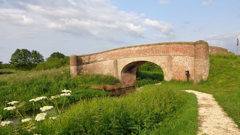
MELBOURNE POCKLINGTON CANAL
SE 74 SE
8/45 Church Bridge
GV II
Road bridge over canal. Early C19. Red brick in English garden wall bond,
gritstone dressings. Basket arch over canal and tow paths flanked by semi-
cylindrical coped buttresses. Band to ramped bridge deck. Coped parapet
ending in cylindrical abutments to splays. Scheduled Ancient Monument.
Listing NGR: SE7585544410
External links are from the relevant listing authority and, where applicable, Wikidata. Wikidata IDs may be related buildings as well as this specific building. If you want to add or update a link, you will need to do so by editing the Wikidata entry.


Other nearby listed buildings
