Latitude: 51.7529 / 51°45'10"N
Longitude: -0.3414 / 0°20'29"W
OS Eastings: 514582
OS Northings: 207320
OS Grid: TL145073
Mapcode National: GBR H89.4GL
Mapcode Global: VHGPQ.16BL
Plus Code: 9C3XQM35+4C
Entry Name: 25, Verulam Road
Listing Date: 27 August 1971
Grade: II
Source: Historic England
Source ID: 1347192
English Heritage Legacy ID: 163469
ID on this website: 101347192
Location: St Albans, St. Albans, Hertfordshire, AL3
County: Hertfordshire
District: St. Albans
Electoral Ward/Division: Verulam
Parish: Non Civil Parish
Built-Up Area: St Albans
Traditional County: Hertfordshire
Lieutenancy Area (Ceremonial County): Hertfordshire
Church of England Parish: Abbey Parish of St Albans
Church of England Diocese: St.Albans
Tagged with: Building
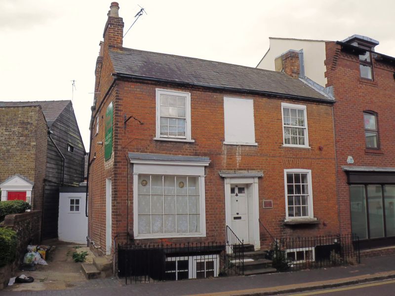
VERULAM ROAD
1. (South-West Side)
1582
No 25
TL 1407 SE 9/307
II
2.
Incorporating the former No 23.
Early C19, 2 storeys and basement, 3 windows. Red brick. Double-span
roof of moderate pitch with large slates. Brick eaves cornice. lst floor
sash windows with glazing bars in flush, moulded frames. Centre window
blocked. Ground floor left earlier Cl9 type shop window; and at right
a sash window with glazing bars in flush, box frame under gauged, segmental,
brick arch. 4 steps to central door of 2 glass and 4 flat panels in
panelled reveal with wood pilasters and cornice hood. Small shop in
basement.
Listing NGR: TL1458207320
External links are from the relevant listing authority and, where applicable, Wikidata. Wikidata IDs may be related buildings as well as this specific building. If you want to add or update a link, you will need to do so by editing the Wikidata entry.


Other nearby listed buildings