Latitude: 51.9468 / 51°56'48"N
Longitude: -0.0188 / 0°1'7"W
OS Eastings: 536264
OS Northings: 229445
OS Grid: TL362294
Mapcode National: GBR K8W.VFN
Mapcode Global: VHGNX.MBDD
Plus Code: 9C3XWXWJ+PF
Entry Name: Black Bull Public House
Listing Date: 22 February 1967
Last Amended: 6 July 1984
Grade: II
Source: Historic England
Source ID: 1347994
English Heritage Legacy ID: 159751
Also known as: Black Bull
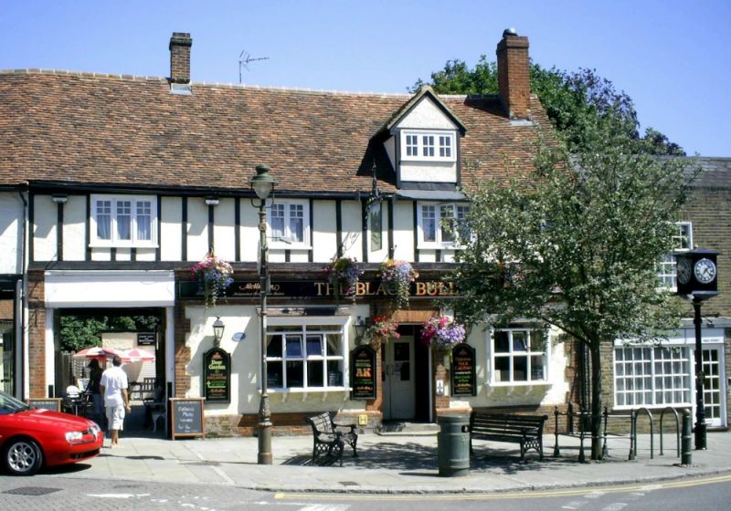
The Black Bull, Buntingford
ID on this website: 101347994
Location: Buntingford, East Hertfordshire, SG9
County: Hertfordshire
District: East Hertfordshire
Town: East Hertfordshire
Civil Parish: Buntingford
Built-Up Area: Buntingford
Traditional County: Hertfordshire
Lieutenancy Area (Ceremonial County): Hertfordshire
Church of England Parish: Layston with Buntingford
Church of England Diocese: St.Albans
Tagged with: Pub
TL 3629 BUNTINGFORD HIGH STREET (east side)
7/9 No 16 (Black Bull P.H. ) 22.2.67 (formerly listed as the Black Bull Inn No 16)
GV II
Inn, now a P.H., C16 or earlier, C19 rear range, front altered in early C20. Timber frame, front half-timbered above red brick and rendered Ground floor. Red-brick rear extension. Steep old red tile roof. 2-storeys, cellar and attic, 4-windows long front facing W extending over carriageway at N end leading to yard. Internal gable chimney at S, and central chimney a quarter from N. A 4-bay framed structure with stair rising at rear of 2nd bay from S. The front has casement windows on the 1st floor with small panes in the head of each light. Large bracketed oriel windows flank the door up 2 steps. A gabled dormer rises over the eaves. Interior has exposed heavy flat joists and axial beams over lofty Ground floor (moulded beam to middle bay), elaborate late C17 straight stair with balusters, tall carved finials to newel posts and similar brackets on posts next to the stair, and a clasped-purlin roof with curved wind-braces. Named The Horseshoes up to 1727.
Listing NGR: TL3626729451
External links are from the relevant listing authority and, where applicable, Wikidata. Wikidata IDs may be related buildings as well as this specific building. If you want to add or update a link, you will need to do so by editing the Wikidata entry.


Other nearby listed buildings