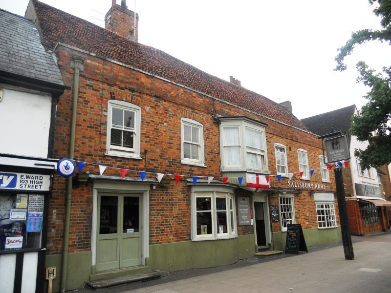
Latitude: 51.7616 / 51°45'41"N
Longitude: -0.0118 / 0°0'42"W
OS Eastings: 537306
OS Northings: 208858
OS Grid: TL373088
Mapcode National: GBR KC6.HTY
Mapcode Global: VHGPP.RZ3G
Plus Code: 9C3XQX6Q+J7
Entry Name: The Salisbury Arms
Listing Date: 13 April 1961
Last Amended: 8 November 1983
Grade: II
Source: Historic England
Source ID: 1348401
English Heritage Legacy ID: 157487
Also known as: The Star
Star
ID on this website: 101348401
Location: Hoddesdon, Broxbourne, Hertfordshire, EN11
County: Hertfordshire
District: Broxbourne
Electoral Ward/Division: Hoddesdon North
Parish: Non Civil Parish
Built-Up Area: Hoddesdon
Traditional County: Hertfordshire
Lieutenancy Area (Ceremonial County): Hertfordshire
Church of England Parish: Hoddesdon
Church of England Diocese: St.Albans
Tagged with: Pub
1.
5251
TL 3708 NW
6a/29
13.4.61
HODDESDON
HIGH STREET
(west side)
Hoddesdon
The Salisbury Arms
(Formerly listed as The Salisbury Arms Hotel and Premises Occupied by N.Godfrey)
II
GV
2.
C16, refronted C18, ground floor details c1820. Red brick, old
tile roof. 2 storeys, parapet. Bands above ground and 1st
floors. 5 1st floor segmental-headed sash windows and canted
oriel. Central door with fluted pilasters, lattice work fan,
bracketed curved hood with grooving, beading and paterae.
Similar details on S side: 3-light bow windows and S-end double
doors. 2 red-brick chimney stacks N and S. 3 timber frame bays,
centre one inside has v-shaped, moulded floor beam. Later bay on
S. C19 one and a half storey rear extension, former brewery: T-
plan, painted brick, machine tile roof, small pane casements and
weatherboarded sack hoist.
Listing NGR: TL3730608858
External links are from the relevant listing authority and, where applicable, Wikidata. Wikidata IDs may be related buildings as well as this specific building. If you want to add or update a link, you will need to do so by editing the Wikidata entry.


Other nearby listed buildings